1940s Maps of Lancaster, Oregon
Explore 4 historic maps of Lancaster from the 1940s. These maps offer a rare glimpse into what life looked like during the 1940s — showing old roads, neighborhoods, homes, and landmarks that have changed or disappeared over time.
Whether you're researching your family's past, planning a metal detecting trip, or studying how Lancaster's landscape evolved across the 1940s, these high-resolution maps are a powerful tool for exploring the history of this region.
- Focus on a specific era: All maps on this page are from the 1940s, giving you a focused view of this time period.
- See what’s changed: Compare century-old streets, trails, and buildings to today's modern landscape using overlays and satellite layers.
- Research with precision: Use these maps for genealogy, historical research, land use analysis, or educational projects.
- View, download, or print: Maps are fully viewable online in high resolution, and can be downloaded or printed for your own records.
Start exploring Lancaster's history through authentic maps from the 1940s. This is your window into the past.
Lancaster, OR maps
(4)- 1940 Map of Eugene
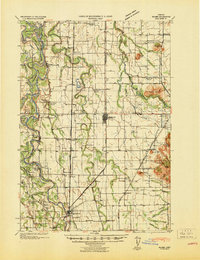
 1940 Eugene1940 Print · USGSThe Willamette Valley at the end of the Great Depression shows a landscape of growing towns and busy rail corridors. Genealogists can locate family-named landmarks like Gillespie Butte School and the I O O F Cemetery.2 unique versions available
 - 1941 Map of Halsey
 1941 Halsey1941 Print · USGSLinn County agriculture and river commerce are on full display during the early 1940s as rail and ferry networks connected the Willamette valley. Genealogists can locate family landmarks like Bell Plain School, the Irish Bend Ferry, and the Pine Grove Church.
 - 1946 Map of Eugene, 1957 Print
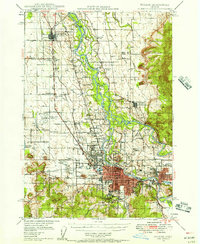 1946 Eugene1957 Print · USGSThe Willamette Valley was a bustling corridor of rail and river commerce just after the war. Researchers can trace the development of Eugene and Springfield, locate family landmarks like the I O O F Cemetery, and follow the path of the Oregon Electric Railroad.2 unique versions available
 - 1949 Map of Eugene
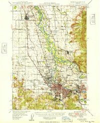 1949 Eugene1949 Print · USGSThe southern Willamette Valley thrived at mid-century as a rail and aviation hub connecting Junction City and Springfield. Researchers can trace old property lines through local landmarks like Lone Pine Sch and the I O O F Cemetery.
End of results
Showing maps 1-4 of 4
Top cities near Lancaster
- Eugene historical maps
- Springfield historical maps
- Junction City historical maps
- Veneta historical maps
- Harrisburg historical maps
- Elmira historical maps
See more
Frequently asked questions
- What are the different types of historical maps available for Lancaster?
- What is the oldest map of Lancaster?
- Where can I purchase historical maps of Lancaster for my home or office?
- Where can I download high-res historical maps of Lancaster?
- Are there historical topographic maps available for Lancaster?
- Is there historical aerial imagery available for Lancaster?
- Where are historical maps of Lancaster sourced from?