1980s Maps of Detroit, Oregon
Explore 2 historic maps of Detroit from the 1980s. These maps offer a rare glimpse into what life looked like during the 1980s — showing old roads, neighborhoods, homes, and landmarks that have changed or disappeared over time.
Whether you're researching your family's past, planning a metal detecting trip, or studying how Detroit's landscape evolved across the 1980s, these high-resolution maps are a powerful tool for exploring the history of this region.
- Focus on a specific era: All maps on this page are from the 1980s, giving you a focused view of this time period.
- See what’s changed: Compare century-old streets, trails, and buildings to today's modern landscape using overlays and satellite layers.
- Research with precision: Use these maps for genealogy, historical research, land use analysis, or educational projects.
- View, download, or print: Maps are fully viewable online in high resolution, and can be downloaded or printed for your own records.
Start exploring Detroit's history through authentic maps from the 1980s. This is your window into the past.
Detroit, OR maps
(2)- 1983 Map of North Santiam River, 1984 Print
 1983 North Santiam River1984 Print · USGSThe western Cascades and Willamette Valley transition in the early eighties, from the state capital to the high timberlands. Genealogists and historians can trace rail lines like the Southern Pacific and explore communities from Mill City to Silver Falls City.
 - 1985 Map of Detroit
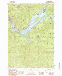 1985 Detroit1985 Print · USGSThe Oregon Cascades meet the waters of the Santiam in the 1980s, centered on the newly established reservoir culture. Local historians can trace the development of Detroit and its surrounding recreation spots like Detroit Lake State Park and Detroit Dam.
End of results
Showing maps 1-2 of 2
Frequently asked questions
- What are the different types of historical maps available for Detroit?
- What is the oldest map of Detroit?
- Where can I purchase historical maps of Detroit for my home or office?
- Where can I download high-res historical maps of Detroit?
- Are there historical topographic maps available for Detroit?
- Is there historical aerial imagery available for Detroit?
- Where are historical maps of Detroit sourced from?