1980s Maps of Drake Crossing, Oregon
Explore 2 historic maps of Drake Crossing from the 1980s. These maps offer a rare glimpse into what life looked like during the 1980s — showing old roads, neighborhoods, homes, and landmarks that have changed or disappeared over time.
Whether you're researching your family's past, planning a metal detecting trip, or studying how Drake Crossing's landscape evolved across the 1980s, these high-resolution maps are a powerful tool for exploring the history of this region.
- Focus on a specific era: All maps on this page are from the 1980s, giving you a focused view of this time period.
- See what’s changed: Compare century-old streets, trails, and buildings to today's modern landscape using overlays and satellite layers.
- Research with precision: Use these maps for genealogy, historical research, land use analysis, or educational projects.
- View, download, or print: Maps are fully viewable online in high resolution, and can be downloaded or printed for your own records.
Start exploring Drake Crossing's history through authentic maps from the 1980s. This is your window into the past.
Drake Crossing, OR maps
(2)- 1983 Map of North Santiam River, 1984 Print
 1983 North Santiam River1984 Print · USGSThe western Cascades and Willamette Valley transition in the early eighties, from the state capital to the high timberlands. Genealogists and historians can trace rail lines like the Southern Pacific and explore communities from Mill City to Silver Falls City.
 - 1985 Map of Drake Crossing
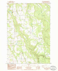 1985 Drake Crossing1985 Print · USGSMarion County in the mid-1980s reveals a landscape defined by the spectacular water features of Silver Falls State Park and rural homesteads. Trace historical landmarks from the Cem near Drake Crossing to isolated settlements at Victor and Hoge.
End of results
Showing maps 1-2 of 2
Top cities near Drake Crossing
- Woodburn historical maps
- Silverton historical maps
- Molalla historical maps
- Stayton historical maps
- Mount Angel historical maps
- Aumsville historical maps
See more
Frequently asked questions
- What are the different types of historical maps available for Drake Crossing?
- What is the oldest map of Drake Crossing?
- Where can I purchase historical maps of Drake Crossing for my home or office?
- Where can I download high-res historical maps of Drake Crossing?
- Are there historical topographic maps available for Drake Crossing?
- Is there historical aerial imagery available for Drake Crossing?
- Where are historical maps of Drake Crossing sourced from?