Old Maps of McKay, Oregon for Hiking & Exploration
Hike through history with 9 historic maps of McKay. Explore old trails, ghost towns, and forgotten backroads — perfect for outdoor adventurers and local explorers.
- Rediscover forgotten places: Map out old mining camps, roads, and footpaths that no longer exist on modern maps.
- Layer with modern tools: Combine with LiDAR or satellite views to plan hikes through historical terrain.
- Made for exploration: Popular among hikers, overlanders, and local history lovers.
Use these maps to find adventure and explore the hidden past of McKay.
McKay, OR maps
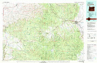
(9)- 1953 Map of Pendleton, 1957 Print
 1953 Pendleton1957 Print · USGSNortheastern Oregon and the Columbia River frontier are captured here in the early fifties, a time of massive federal infrastructure projects. Researchers can trace the historic route of The Old Oregon Trail as it passes near the Umatilla Ordnance Depot and the new McNary Dam.4 unique versions available
 - 1956 Map of Pendleton
 1956 Pendleton1956 Print · USGSNortheastern Oregon’s high plateau and timbered peaks appear here in the mid-fifties, during a time of major military and hydroelectric development. Trace the path of The Old Oregon Trail alongside modern landmarks like McNary Dam and the Umatilla Ordnance Depot.
 - 1967 Map of Bassey Creek, 1969 Print
 1967 Bassey Creek1969 Print · USGSUmatilla County's high ridges and deep canyons are documented here in the late sixties, showing a landscape defined by seasonal camps and traditional boundaries. Researchers can trace the Old Indian Treaty Boundary Road and locate sites like Buckhorn Camp or Storm Mountain.
 - 1979 Map of La Grande, 1980 Print
 1979 La Grande1980 Print · USGSNorthwestern Oregon’s mountain corridors are captured here in the late seventies, showing the rail and river networks through the Blue Mountains. Trace the Old Emigrant Road, locate the Aurelia Mine, or explore the Starkey Experimental Forest.2 unique versions available
 - 1996 Map of Bassey Creek, 1998 Print
 1996 Bassey Creek1998 Print · USGSUmatilla County in the mid-nineties shows a landscape defined by deep canyons and mountain ridges within the national forest. Local historians and researchers can trace the network of forest roads and 4WD tracks leading to Buckhorn Camp, Johnson Tower, and remote water sources like Mathis Spring.
 - 2014 Map of Bassey Creek, 2014 Print
 2014 Bassey Creek2014 Print · USGSCovers McKay, including Umatilla County, United States, and other nearby areas
 - 2017 Map of Bassey Creek, 2017 Print
 2017 Bassey Creek2017 Print · USGSCovers McKay, including Umatilla County, United States, and other nearby areas
 - 2020 Map of Bassey Creek, 2020 Print
 2020 Bassey Creek2020 Print · USGSCovers McKay, including Umatilla County, United States, and other nearby areas
 - 2023 Map of Bassey Creek, 2023 Print
 2023 Bassey Creek2023 Print · USGSUmatilla County's high country is documented here in the early twenty-first century, showing the intricate canyons and ridges of the Blue Mountain foothills. Researchers can locate named landmarks like Storm Mtn and remote water sources including Mathis Spring and Elder Spring.
End of results
Showing maps 1-9 of 9
Top cities near McKay
Frequently asked questions
- What are the different types of historical maps available for McKay?
- What is the oldest map of McKay?
- Where can I purchase historical maps of McKay for my home or office?
- Where can I download high-res historical maps of McKay?
- Are there historical topographic maps available for McKay?
- Is there historical aerial imagery available for McKay?
- Where are historical maps of McKay sourced from?