Old Maps of Tollgate, Oregon for Metal Detecting
Plan your next treasure hunt with 9 historic maps of Tollgate. Find old homesites, ghost towns, trails, and gathering spots that may be lost to time — perfect for identifying promising metal detecting locations.
- Locate forgotten sites: Uncover places like long-lost settlements, abandoned rail lines, or gathering spots.
- Plan better hunts: Use map overlays combined with LiDAR or satellite views to narrow in on historically rich areas.
- Made for detectorists: Thousands of hobbyists use these maps to discover relics, coins, and hidden history.
Use these historic maps to boost your research and find new opportunities beneath the surface of Tollgate.
Tollgate, OR maps
(9)- 1953 Map of Pendleton, 1957 Print
 1953 Pendleton1957 Print · USGSNortheastern Oregon and the Columbia River frontier are captured here in the early fifties, a time of massive federal infrastructure projects. Researchers can trace the historic route of The Old Oregon Trail as it passes near the Umatilla Ordnance Depot and the new McNary Dam.4 unique versions available
 - 1956 Map of Pendleton
 1956 Pendleton1956 Print · USGSNortheastern Oregon’s high plateau and timbered peaks appear here in the mid-fifties, during a time of major military and hydroelectric development. Trace the path of The Old Oregon Trail alongside modern landmarks like McNary Dam and the Umatilla Ordnance Depot.
 - 1963 Map of Tollgate, 1965 Print
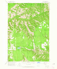 1963 Tollgate1965 Print · USGSThe high country of the Blue Mountains comes into focus in the early sixties, showing a landscape of forest camps and fire lookouts. Researchers can locate Langdon Lake and Tollgate, or trace the network of trails around Bear Creek Guard Station and McIntyre Lookout.3 unique versions available
 - 1983 Map of Pendleton, 1984 Print
 1983 Pendleton1984 Print · USGSPendleton and the Blue Mountain foothills are captured here in the early eighties as a hub of rail, ranching, and forest management. Genealogists and historians can trace local landmarks like Indian Agency Hdqrs, Bingham Springs, and the Union Pacific line.
 - 1995 Map of Tollgate, 1998 Print
 1995 Tollgate1998 Print · USGSThe Umatilla highlands in the mid-1990s are defined here by mountain lookouts and the high-altitude waters of Langdon Lake. Researchers can trace old forest routes and landmarks like McIntyre Lookout, Target Meadows, and the Tollgate settlement area.
 - 2011 Map of Tollgate, 2011 Print
 2011 Tollgate2011 Print · USGSCovers Tollgate, including Umatilla County, Union County, and other nearby areas
 - 2014 Map of Tollgate, 2014 Print
 2014 Tollgate2014 Print · USGSCovers Tollgate, including Umatilla County, Union County, and other nearby areas
 - 2020 Map of Tollgate, 2020 Print
 2020 Tollgate2020 Print · USGSCovers Tollgate, including Umatilla County, Union County, and other nearby areas
 - 2024 Map of Tollgate, 2024 Print
 2024 Tollgate2024 Print · USGSTollgate and the high country of the Blue Mountains are captured here in recent detail, showing the intersection of Umatilla and Union counties. Modern researchers can locate the shores of Langdon Lake, the clearings at Target Meadows, and the winding Eagle Ridge Trl.
End of results
Showing maps 1-9 of 9
Top cities near Tollgate
Frequently asked questions
- What are the different types of historical maps available for Tollgate?
- What is the oldest map of Tollgate?
- Where can I purchase historical maps of Tollgate for my home or office?
- Where can I download high-res historical maps of Tollgate?
- Are there historical topographic maps available for Tollgate?
- Is there historical aerial imagery available for Tollgate?
- Where are historical maps of Tollgate sourced from?