1990s Maps of Champion, North Fayette Township
Explore 1 historic maps of Champion from the 1990s. These maps offer a rare glimpse into what life looked like during the 1990s — showing old roads, neighborhoods, homes, and landmarks that have changed or disappeared over time.
Whether you're researching your family's past, planning a metal detecting trip, or studying how Champion's landscape evolved across the 1990s, these high-resolution maps are a powerful tool for exploring the history of this region.
- Focus on a specific era: All maps on this page are from the 1990s, giving you a focused view of this time period.
- See what’s changed: Compare century-old streets, trails, and buildings to today's modern landscape using overlays and satellite layers.
- Research with precision: Use these maps for genealogy, historical research, land use analysis, or educational projects.
- View, download, or print: Maps are fully viewable online in high resolution, and can be downloaded or printed for your own records.
Start exploring Champion's history through authentic maps from the 1990s. This is your window into the past.
Champion, North Fayette Township maps
(1)- 1998 Map of Clinton, 2000 Print
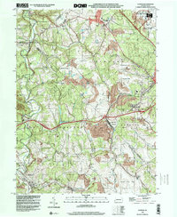 1998 Clinton2000 Print · USGSWestern Pennsylvania at the end of the century reveals a landscape shaped by heavy industry and aviation. Researchers can trace family sites near Hebron Ch, explore the footprint of Imperial, or study the impact of Reclaimed Strip Mines and the Greater Pittsburgh International Airport.
End of results
Showing maps 1-1 of 1
Top cities near Champion
- Pittsburgh historical maps
- Bethel Park historical maps
- Mount Lebanon historical maps
- McCandless historical maps
- Moon Township historical maps
- Upper St. Clair historical maps
See more
Frequently asked questions
- What are the different types of historical maps available for Champion?
- What is the oldest map of Champion?
- Where can I purchase historical maps of Champion for my home or office?
- Where can I download high-res historical maps of Champion?
- Are there historical topographic maps available for Champion?
- Is there historical aerial imagery available for Champion?
- Where are historical maps of Champion sourced from?