1960s Maps of O'Hara Township, Pennsylvania
Explore 5 historic maps of O'Hara Township from the 1960s. These maps offer a rare glimpse into what life looked like during the 1960s — showing old roads, neighborhoods, homes, and landmarks that have changed or disappeared over time.
Whether you're researching your family's past, planning a metal detecting trip, or studying how O'Hara Township's landscape evolved across the 1960s, these high-resolution maps are a powerful tool for exploring the history of this region.
- Focus on a specific era: All maps on this page are from the 1960s, giving you a focused view of this time period.
- See what’s changed: Compare century-old streets, trails, and buildings to today's modern landscape using overlays and satellite layers.
- Research with precision: Use these maps for genealogy, historical research, land use analysis, or educational projects.
- View, download, or print: Maps are fully viewable online in high resolution, and can be downloaded or printed for your own records.
Start exploring O'Hara Township's history through authentic maps from the 1960s. This is your window into the past.
O'Hara Township, PA maps
(5)- 1960 Map of Braddock, 1961 Print
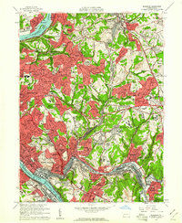 1960 Braddock1961 Print · USGSEastern Allegheny County's industrial and suburban heartland is captured here during the mid-century growth of the 1960s. Trace the intricate rail yards at North Bessemer Yards or locate local landmarks like Woodlawn Cemetery and the Wilkinsburg-Pittsburgh Airport.5 unique versions available
 - 1960 Map of New Kensington West, 1961 Print
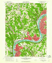 1960 New Kensington West1961 Print · USGSThe industrial Allegheny River corridor hums with activity in the 1960s, anchoring a chain of river towns and rail hubs. Researchers can trace the mid-century development of Oakmont, Cheswick, and New Kensington alongside landmarks like Lock and Dam No 3 and Remich Airport.4 unique versions available
 - 1960 Map of Pittsburgh East, 1961 Print
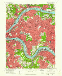 1960 Pittsburgh East1961 Print · USGSPostwar Pittsburgh and its eastern boroughs are captured here at their industrial height, bounded by the great river bends. Genealogists and local historians can trace legacy parish boundaries through St Marys Cem, Peabody High Sch, and St Aloysius Ch.4 unique versions available
 - 1960 Map of Glenshaw, 1961 Print
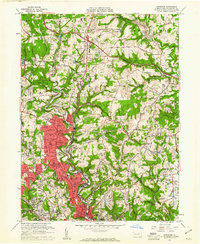 1960 Glenshaw1961 Print · USGSAllegheny County at the start of the sixties shows a dense network of suburban expansion and industrial transport north of Pittsburgh. Genealogists can trace family names and sites across numerous burial grounds like Mt Royal Cemetery and Beth Shalom Cemetery or locate landmarks like the Radio Sta (KDKA) and Shady Side Academy.6 unique versions available
 - 1964 Map of Pittsburgh
 1964 Pittsburgh1964 Print · USGSWestern Pennsylvania in the late fifties and early sixties shows a landscape of powerful river industries and expanding highways. Genealogists and historians can trace the rail corridors of the Pennsylvania RR through industrial hubs like Johnstown, Altoona, and Nanty Glo.
End of results
Showing maps 1-5 of 5
Top cities near O'Hara Township
- Pittsburgh historical maps
- Penn Hills historical maps
- Bethel Park historical maps
- Ross Township historical maps
- Mount Lebanon historical maps
- McCandless historical maps
See more
Top neighborhoods of O'Hara Township
Frequently asked questions
- What are the different types of historical maps available for O'Hara Township?
- What is the oldest map of O'Hara Township?
- Where can I purchase historical maps of O'Hara Township for my home or office?
- Where can I download high-res historical maps of O'Hara Township?
- Are there historical topographic maps available for O'Hara Township?
- Is there historical aerial imagery available for O'Hara Township?
- Where are historical maps of O'Hara Township sourced from?