1960s Maps of Cowanshannock Township, Pennsylvania
Explore 5 historic maps of Cowanshannock Township from the 1960s. These maps offer a rare glimpse into what life looked like during the 1960s — showing old roads, neighborhoods, homes, and landmarks that have changed or disappeared over time.
Whether you're researching your family's past, planning a metal detecting trip, or studying how Cowanshannock Township's landscape evolved across the 1960s, these high-resolution maps are a powerful tool for exploring the history of this region.
- Focus on a specific era: All maps on this page are from the 1960s, giving you a focused view of this time period.
- See what’s changed: Compare century-old streets, trails, and buildings to today's modern landscape using overlays and satellite layers.
- Research with precision: Use these maps for genealogy, historical research, land use analysis, or educational projects.
- View, download, or print: Maps are fully viewable online in high resolution, and can be downloaded or printed for your own records.
Start exploring Cowanshannock Township's history through authentic maps from the 1960s. This is your window into the past.
Cowanshannock Township, PA maps
(5)- 1964 Map of Pittsburgh
 1964 Pittsburgh1964 Print · USGSWestern Pennsylvania in the late fifties and early sixties shows a landscape of powerful river industries and expanding highways. Genealogists and historians can trace the rail corridors of the Pennsylvania RR through industrial hubs like Johnstown, Altoona, and Nanty Glo.
 - 1964 Map of Elderton, 1966 Print
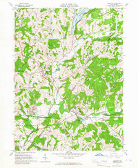 1964 Elderton1966 Print · USGSThe Armstrong and Indiana county border comes alive in the mid-sixties, showing a landscape of deep valleys and expanding gas fields. Researchers can locate family sites near Elderton, trace the Baltimore and Ohio line, or find Salem Ch and St Jacobs Ch.3 unique versions available
 - 1968 Map of Plumville, 1971 Print
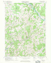 1968 Plumville1971 Print · USGSIndiana and Armstrong counties meet in this late 1960s survey of Pennsylvania's rolling plateau and creek valleys. Genealogists and historians can trace numerous rural burial sites like Sacred Heart Cem and industry markers such as Hoosicks Mill.3 unique versions available
 - 1968 Map of Mosgrove, 1972 Print
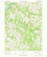 1968 Mosgrove1972 Print · USGSArmstrong County in the late 1960s shows a landscape of rail-and-river transport and burgeoning energy extraction. Trace ancestral roots through rural sites like Rupp Cem, Pine Furnace, and the old Township Sch near Sunnyside.4 unique versions available
 - 1969 Map of Rural Valley, 1972 Print
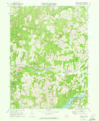 1969 Rural Valley1972 Print · USGSArmstrong County's mining and gas-drilling heritage is on full display in the late sixties. Genealogists and historians can trace family roots near Rural Valley, NuMine, and Yatesboro, or locate rural churches like St Michaels Ch.3 unique versions available
End of results
Showing maps 1-5 of 5
Top cities near Cowanshannock Township
- Indiana historical maps
- Kittanning historical maps
- Rayne Township historical maps
- North Buffalo Township historical maps
- Brush Valley Township historical maps
- Mahoning historical maps
See more
Top neighborhoods of Cowanshannock Township
- NuMine historical maps
- Bryan historical maps
- Margaret historical maps
- Meredith historical maps
- Smeltzer historical maps
- Yatesboro historical maps
See more
Frequently asked questions
- What are the different types of historical maps available for Cowanshannock Township?
- What is the oldest map of Cowanshannock Township?
- Where can I purchase historical maps of Cowanshannock Township for my home or office?
- Where can I download high-res historical maps of Cowanshannock Township?
- Are there historical topographic maps available for Cowanshannock Township?
- Is there historical aerial imagery available for Cowanshannock Township?
- Where are historical maps of Cowanshannock Township sourced from?