1990s Maps of Kittanning, Armstrong County
Explore 2 historic maps of Kittanning from the 1990s. These maps offer a rare glimpse into what life looked like during the 1990s — showing old roads, neighborhoods, homes, and landmarks that have changed or disappeared over time.
Whether you're researching your family's past, planning a metal detecting trip, or studying how Kittanning's landscape evolved across the 1990s, these high-resolution maps are a powerful tool for exploring the history of this region.
- Focus on a specific era: All maps on this page are from the 1990s, giving you a focused view of this time period.
- See what’s changed: Compare century-old streets, trails, and buildings to today's modern landscape using overlays and satellite layers.
- Research with precision: Use these maps for genealogy, historical research, land use analysis, or educational projects.
- View, download, or print: Maps are fully viewable online in high resolution, and can be downloaded or printed for your own records.
Start exploring Kittanning's history through authentic maps from the 1990s. This is your window into the past.
Kittanning, Armstrong County maps
(2)- 1993 Map of Kittanning
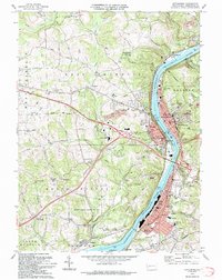 1993 Kittanning1993 Print · USGSArmstrong County in the 1990s was a landscape shaped by the Allegheny River and a legacy of industry. Genealogists and historians can trace family roots through numerous sites like Lawnheaven Cem, Wick City, and the St Pauls Monastery.
 - 1998 Map of Kittanning, 2000 Print
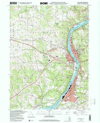 1998 Kittanning2000 Print · USGSArmstrong County’s riverfront industrial corridor is captured here at the end of the century, showing the tight-knit settlements along the Allegheny. Researchers can trace local roots through St Pauls Monastery, Dog Town, and Holy Trinity Cem.
End of results
Showing maps 1-2 of 2
Frequently asked questions
- What are the different types of historical maps available for Kittanning?
- What is the oldest map of Kittanning?
- Where can I purchase historical maps of Kittanning for my home or office?
- Where can I download high-res historical maps of Kittanning?
- Are there historical topographic maps available for Kittanning?
- Is there historical aerial imagery available for Kittanning?
- Where are historical maps of Kittanning sourced from?