1960s Maps of Redbank Township, Pennsylvania
Explore 5 historic maps of Redbank Township from the 1960s. These maps offer a rare glimpse into what life looked like during the 1960s — showing old roads, neighborhoods, homes, and landmarks that have changed or disappeared over time.
Whether you're researching your family's past, planning a metal detecting trip, or studying how Redbank Township's landscape evolved across the 1960s, these high-resolution maps are a powerful tool for exploring the history of this region.
- Focus on a specific era: All maps on this page are from the 1960s, giving you a focused view of this time period.
- See what’s changed: Compare century-old streets, trails, and buildings to today's modern landscape using overlays and satellite layers.
- Research with precision: Use these maps for genealogy, historical research, land use analysis, or educational projects.
- View, download, or print: Maps are fully viewable online in high resolution, and can be downloaded or printed for your own records.
Start exploring Redbank Township's history through authentic maps from the 1960s. This is your window into the past.
Redbank Township, PA maps
(5)- 1964 Map of Pittsburgh
 1964 Pittsburgh1964 Print · USGSWestern Pennsylvania in the late fifties and early sixties shows a landscape of powerful river industries and expanding highways. Genealogists and historians can trace the rail corridors of the Pennsylvania RR through industrial hubs like Johnstown, Altoona, and Nanty Glo.
 - 1968 Map of Dayton, 1971 Print
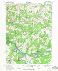 1968 Dayton1971 Print · USGSThe hills of Armstrong and Jefferson counties were deeply shaped by coal and rail during the late sixties. Researchers can trace the legacy of extractive industry and rural life through Strip Mines, the Dayton High Sch, and family landmarks like St James Cem.4 unique versions available
 - 1969 Map of Distant, 1972 Print
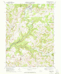
 1969 Distant1972 Print · USGSArmstrong County is shaped by heavy industry and deep river valleys in the late sixties, just as the regional landscape was being transformed by resource extraction. Genealogists can trace family roots through sites like Oakland Cem or Jerusalem Ch while following the path of the Penn Central through South Bethlehem.3 unique versions available
 - 1969 Map of Summerville, 1972 Print
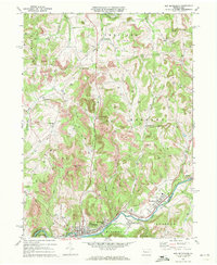
 1969 Summerville1972 Print · USGSJefferson and Clarion counties are shown in the late sixties as the region's rail and mining industries shaped the landscape. Genealogists and historians can trace family locations near Summerville, Bethlehem Cem, and the Content schoolhouse.3 unique versions available
 - 1969 Map of New Bethlehem, 1972 Print
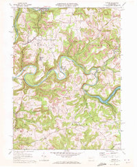
 1969 New Bethlehem1972 Print · USGSThe Redbank Creek valley in the late 1960s was a bustling hub of rail and industry. Researchers can trace the legacy of the Gas Field and Strip Mine workings surrounding New Bethlehem, Hawthorn, and Fairmount City.2 unique versions available
End of results
Showing maps 1-5 of 5
Top cities near Redbank Township
- Clarion historical maps
- Brookville historical maps
- Rayne Township historical maps
- Limestone Township historical maps
- Mahoning historical maps
- Warsaw Township historical maps
See more
Top neighborhoods of Redbank Township
- Oak Ridge historical maps
- McWilliams historical maps
- Charlestown historical maps
- Eddyville historical maps
- Mount Tabor historical maps
- New Salem historical maps
See more
Frequently asked questions
- What are the different types of historical maps available for Redbank Township?
- What is the oldest map of Redbank Township?
- Where can I purchase historical maps of Redbank Township for my home or office?
- Where can I download high-res historical maps of Redbank Township?
- Are there historical topographic maps available for Redbank Township?
- Is there historical aerial imagery available for Redbank Township?
- Where are historical maps of Redbank Township sourced from?