1990s Maps of Asylum Township, Pennsylvania
Explore 3 historic maps of Asylum Township from the 1990s. These maps offer a rare glimpse into what life looked like during the 1990s — showing old roads, neighborhoods, homes, and landmarks that have changed or disappeared over time.
Whether you're researching your family's past, planning a metal detecting trip, or studying how Asylum Township's landscape evolved across the 1990s, these high-resolution maps are a powerful tool for exploring the history of this region.
- Focus on a specific era: All maps on this page are from the 1990s, giving you a focused view of this time period.
- See what’s changed: Compare century-old streets, trails, and buildings to today's modern landscape using overlays and satellite layers.
- Research with precision: Use these maps for genealogy, historical research, land use analysis, or educational projects.
- View, download, or print: Maps are fully viewable online in high resolution, and can be downloaded or printed for your own records.
Start exploring Asylum Township's history through authentic maps from the 1990s. This is your window into the past.
Asylum Township, PA maps
(3)- 1998 Map of Towanda, 1999 Print
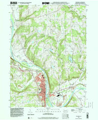 1998 Towanda1999 Print · USGSBradford County’s riverfront settlements and upland valleys are captured here at the close of the century. Genealogists and local historians can trace family plots at Oak Hill Cemetery and Ghent Cem, or locate the old Drive-in Theater and Fairgrounds near East Towanda.
 - 1999 Map of Monroeton, 2001 Print
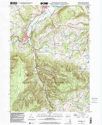 1999 Monroeton2001 Print · USGSBradford County near the turn of the millennium shows a landscape where river valley industry meets high forest ridges. Genealogists and hikers can trace the Old Railroad Grade and locate family sites like Cole Cem or the settlement at Kellogg.
 - 1999 Map of Wyalusing, 2001 Print
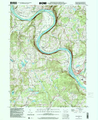 1999 Wyalusing2001 Print · USGSBradford County’s river valley is centered here during the late nineties, where the Susquehanna's dramatic bends shaped local settlement patterns. Genealogists can trace family footprints near French Asylum, Terrytown, and the historic Standing Stone Ch.
End of results
Showing maps 1-3 of 3
Top cities near Asylum Township
- Towanda historical maps
- Wysox Township historical maps
- Sheshequin Township historical maps
- Litchfield Township historical maps
- Ulster Township historical maps
- Wilmot Township historical maps
See more
Top neighborhoods of Asylum Township
Frequently asked questions
- What are the different types of historical maps available for Asylum Township?
- What is the oldest map of Asylum Township?
- Where can I purchase historical maps of Asylum Township for my home or office?
- Where can I download high-res historical maps of Asylum Township?
- Are there historical topographic maps available for Asylum Township?
- Is there historical aerial imagery available for Asylum Township?
- Where are historical maps of Asylum Township sourced from?