Old Maps of South Waverly, Bradford County for Genealogy
Trace your family roots with 22 historic maps of South Waverly. These high-res maps reveal old neighborhoods, homesites, landmarks, and streets — helping you uncover where your ancestors lived and how the area evolved over time.
- Explore historic neighborhoods: Identify where your relatives may have lived in the 1800s or 1900s.
- Compare maps over time: Trace the changes in streets, buildings, and landmarks for multi-generational research.
- Perfect for genealogy & ancestry research: Used by family historians and researchers to map out lineage and migration.
These maps are an incredible resource for exploring your personal connection to South Waverly's past.
South Waverly, Bradford County maps
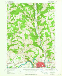
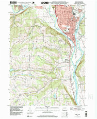
(22)- 1902 Map of Waverly
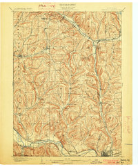 1902 Waverly1902 Print · USGSCovers South Waverly, including Horseheads, Barton, and other nearby areas7 unique versions available
 - 1905 Map of Watkins Glen
 1905 Watkins Glen1905 Print · USGSCovers South Waverly, including Ithaca, Elmira, and other nearby areas4 unique versions available
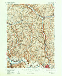
 - 1939 Map of Sayre, 1966 Print
 1939 Sayre1966 Print · USGSCovers South Waverly, including Barton, Sayre, and other nearby areas
 - 1942 Map of Sayre
 1942 Sayre1942 Print · USGSCovers South Waverly, including Barton, Sayre, and other nearby areas2 unique versions available
 - 1948 Map of Sayre
 1948 Sayre1948 Print · USGSCovers South Waverly, including Barton, Sayre, and other nearby areas3 unique versions available
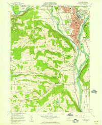
 - 1950 Map of Elmira
 1950 Elmira1950 Print · USGSCovers South Waverly, including Syracuse, Union, and other nearby areas2 unique versions available
 - 1954 Map of Williamsport
 1954 Williamsport1954 Print · USGSCovers South Waverly, including Vestal, Williamsport, and other nearby areas
 - 1954 Map of Waverly, 1956 Print
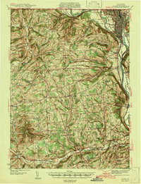
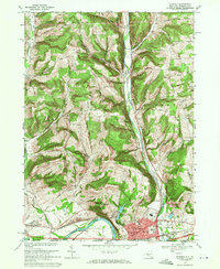
 1954 Waverly1956 Print · USGSCovers South Waverly, including Barton, Waverly, and other nearby areas2 unique versions available
 - 1954 Map of Waverly, 1961 Print
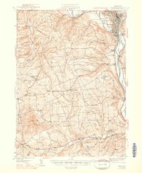
 1954 Waverly1961 Print · USGSCovers South Waverly, including Horseheads, Barton, and other nearby areas2 unique versions available
 - 1957 Map of Sayre, 1958 Print
 1957 Sayre1958 Print · USGSCovers South Waverly, including Barton, Sayre, and other nearby areas4 unique versions available
 - 1958 Map of Elmira
 1958 Elmira1958 Print · USGSCovers South Waverly, including Syracuse, Union, and other nearby areas2 unique versions available
 - 1960 Map of Williamsport
 1960 Williamsport1960 Print · USGSCovers South Waverly, including Vestal, Williamsport, and other nearby areas
 - 1962 Map of Williamsport, 1966 Print
 1962 Williamsport1966 Print · USGSCovers South Waverly, including Vestal, Williamsport, and other nearby areas5 unique versions available
 - 1962 Map of Elmira, 1969 Print
 1962 Elmira1969 Print · USGSCovers South Waverly, including Syracuse, Union, and other nearby areas4 unique versions available
 - 1965 Map of Elmira
 1965 Elmira1965 Print · USGSCovers South Waverly, including Syracuse, Union, and other nearby areas
 - 1965 Map of Williamsport
 1965 Williamsport1965 Print · USGSCovers South Waverly, including Vestal, Williamsport, and other nearby areas
 - 1966 Map of Williamsport
 1966 Williamsport1966 Print · USGSCovers South Waverly, including Vestal, Williamsport, and other nearby areas
 - 1969 Map of Waverly, 1971 Print
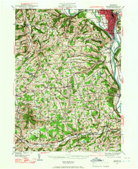
 1969 Waverly1971 Print · USGSCovers South Waverly, including Barton, Waverly, and other nearby areas3 unique versions available
 - 1981 Map of Towanda, 1982 Print
 1981 Towanda1982 Print · USGSCovers South Waverly, including Vestal, Owego, and other nearby areas
 - 1986 Map of Elmira
 1986 Elmira1986 Print · USGSCovers South Waverly, including Union, Ithaca, and other nearby areas
 - 1992 Map of Elmira, 1993 Print
 1992 Elmira1993 Print · USGSCovers South Waverly, including Union, Ithaca, and other nearby areas
 - 1995 Map of Sayre, 1999 Print
 1995 Sayre1999 Print · USGSCovers South Waverly, including Barton, Sayre, and other nearby areas
End of results
Showing maps 1-22 of 22
Frequently asked questions
- What are the different types of historical maps available for South Waverly?
- What is the oldest map of South Waverly?
- Where can I purchase historical maps of South Waverly for my home or office?
- Where can I download high-res historical maps of South Waverly?
- Are there historical topographic maps available for South Waverly?
- Is there historical aerial imagery available for South Waverly?
- Where are historical maps of South Waverly sourced from?