1920s Maps of Towanda, Pennsylvania
Explore 2 historic maps of Towanda from the 1920s. These maps offer a rare glimpse into what life looked like during the 1920s — showing old roads, neighborhoods, homes, and landmarks that have changed or disappeared over time.
Whether you're researching your family's past, planning a metal detecting trip, or studying how Towanda's landscape evolved across the 1920s, these high-resolution maps are a powerful tool for exploring the history of this region.
- Focus on a specific era: All maps on this page are from the 1920s, giving you a focused view of this time period.
- See what’s changed: Compare century-old streets, trails, and buildings to today's modern landscape using overlays and satellite layers.
- Research with precision: Use these maps for genealogy, historical research, land use analysis, or educational projects.
- View, download, or print: Maps are fully viewable online in high resolution, and can be downloaded or printed for your own records.
Start exploring Towanda's history through authentic maps from the 1920s. This is your window into the past.
Towanda, PA maps
(2)- 1923 Map of Towanda
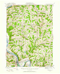 1923 Towanda1923 Print · USGSBradford County in the early twenties shows a bustling river-and-rail landscape centered on the Susquehanna River. Researchers can trace dozens of named schools like Cebu School and Shores Hill School or locate family roots in hamlets like Bumpville and Allis Hollow.
 - 1926 Map of Towanda
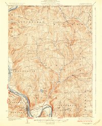 1926 Towanda1926 Print · USGSBradford County was a landscape of concentrated rural communities and river-valley commerce during the mid-twenties. Genealogists and local historians can trace hundreds of property-level details, from the Cottonhollow School to the banks of Lake Wesauking and Wysox.4 unique versions available
End of results
Showing maps 1-2 of 2
Top cities near Towanda
- Sayre historical maps
- Athens historical maps
- Wysox Township historical maps
- Sheshequin Township historical maps
- Litchfield Township historical maps
- Ulster Township historical maps
See more
Frequently asked questions
- What are the different types of historical maps available for Towanda?
- What is the oldest map of Towanda?
- Where can I purchase historical maps of Towanda for my home or office?
- Where can I download high-res historical maps of Towanda?
- Are there historical topographic maps available for Towanda?
- Is there historical aerial imagery available for Towanda?
- Where are historical maps of Towanda sourced from?