1900s (20th Century) Maps of Warrington Township, Pennsylvania
Explore 21 historic maps of Warrington Township from the 1900s (20th Century). These maps offer a rare glimpse into what life looked like during the 1900s — showing old roads, neighborhoods, homes, and landmarks that have changed or disappeared over time.
Whether you're researching your family's past, planning a metal detecting trip, or studying how Warrington Township's landscape evolved across the 1900s, these high-resolution maps are a powerful tool for exploring the history of this region.
- Focus on a specific era: All maps on this page are from the 1900s, giving you a focused view of this time period.
- See what’s changed: Compare century-old streets, trails, and buildings to today's modern landscape using overlays and satellite layers.
- Research with precision: Use these maps for genealogy, historical research, land use analysis, or educational projects.
- View, download, or print: Maps are fully viewable online in high resolution, and can be downloaded or printed for your own records.
Start exploring Warrington Township's history through authentic maps from the 1900s. This is your window into the past.
Warrington Township, PA maps
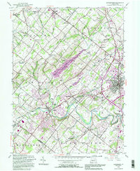
(21)- 1942 Map of Norristown
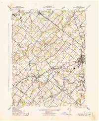
 1942 Norristown1942 Print · USGSSoutheastern Pennsylvania at the onset of World War II shows a landscape of busy industrial river towns and expanding rail suburbs. Genealogists and historians can trace the early transit networks connecting Norristown, Doylestown, and the riverfront at New Hope.
 - 1943 Map of Doylestown
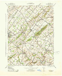
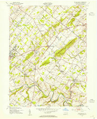
 1943 Doylestown1943 Print · USGSBucks County during the early 1940s reveals a settled landscape of crossroads hamlets and family-named landmarks connected by the Reading railroad. Researchers can trace ancestral roots through sites like Beulah Cemetery, the Farm School, and the Luth Ch Spire in Dublin.
 - 1943 Map of Buckingham
 1943 Buckingham1943 Print · USGSBucks County at the height of the Second World War reveals a landscape of tight-knit rural villages and essential rail connections. Genealogists and historians can trace family roots through landmarks like the Hughesian School, Mt Gilead Church, and stops along the Reading railroad.
 - 1944 Map of Newark, 1971 Print
 1944 Newark1971 Print · USGSThe industrial corridor from Philadelphia to New York was in a period of massive transition during the mid-forties. Genealogists and researchers can trace the rail lines of the Lehigh Valley RR, locate military installations like Picatinny Arsenal, and explore the early sprawl near Levittown.5 unique versions available
 - 1949 Map of Newark
 1949 Newark1949 Print · USGSThe industrial corridor between Philadelphia and New York comes alive in this post-war survey. Genealogists and historians can trace the massive rail networks of the Reading Railroad and locate major installations like Fort Dix or Picatinny Arsenal.2 unique versions available
 - 1952 Map of Hatboro, 1953 Print
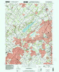
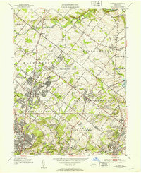 1952 Hatboro1953 Print · USGSGreater Hatboro and Upper Moreland are captured here in the early fifties as postwar suburban growth begins to encircle established rural hamlets. Researchers can trace the massive U S Naval Air Development Center or locate family sites at Richboro Sch and the Southampton Meetinghouse.3 unique versions available
 - 1952 Map of Ambler, 1953 Print
 1952 Ambler1953 Print · USGSSuburban Montgomery County was rapidly evolving in the early fifties as estates gave way to new neighborhoods. Genealogists can trace family names and local landmarks from Ambler to Spring House, including the Rose Valley Cem and the U S Naval Air Station.2 unique versions available
 - 1953 Map of Buckingham, 1954 Print
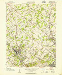
 1953 Buckingham1954 Print · USGSBucks County at mid-century remains a landscape of rolling townships and rural crossroads connected by the Reading Railroad. Genealogists and local historians can trace the foundations of DOYLESTOWN and Buckingham through landmarks like the Buckingham Valley Mill, Bycot Sta, and Mt Gilead Ch.7 unique versions available
 - 1953 Map of Doylestown, 1954 Print
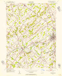 1953 Doylestown1954 Print · USGSBucks County in the early fifties shows a landscape of growing boroughs and deep-rooted rural townships. Researchers can trace ancestral locations through numerous named schoolhouses and local institutions like the National Agricultural College and Beulah Chapel.6 unique versions available
 - 1956 Map of Newark
 1956 Newark1956 Print · USGSThe industrial heart of the Mid-Atlantic is captured here at the dawn of the highway era, tracing the dense corridors between Newark and Philadelphia. Genealogists and local historians can map the rail networks of the Reading RR or locate mid-century military life at Fort Dix Military Reservation.2 unique versions available
 - 1957 Map of Newark
 1957 Newark1957 Print · USGSThe industrial and military heart of the Mid-Atlantic is mapped during its post-war suburban boom. Genealogists and historians can trace the intricate rail corridors of the Reading Railroad and locate key landmarks from Princeton University to Fort Hancock.
 - 1960 Map of Newark
 1960 Newark1960 Print · USGSThe industrial heart of the Mid-Atlantic is shown at mid-century, stretching from the dense urban centers of Newark and Philadelphia to the Blue Mountain ridges. Researchers can trace historic rail lines, coastal defenses at Fort Hancock, and the riverfront growth of Trenton and Easton.3 unique versions available
 - 1964 Map of Newark
 1964 Newark1964 Print · USGSGreater New Jersey and eastern Pennsylvania appear at the peak of their industrial and rail-centered development in the mid-sixties. Genealogists and historians can trace the paths of the Pennsylvania RR, identify mid-century landmarks like CAMP KILMER, or follow the Schuylkill River through READING.2 unique versions available
 - 1966 Map of Hatboro, 1968 Print
 1966 Hatboro1968 Print · USGSMid-century Montgomery and Bucks Counties are captured here as suburban growth surrounds established towns like Hatboro and Willow Grove. Researchers can trace the sprawling U S Naval Air Development Center or locate family sites at Neshaminy Cem and Bryn Athyn Academy.3 unique versions available
 - 1966 Map of Ambler, 1968 Print
 1966 Ambler1968 Print · USGSMid-century Montgomery County is seen here during a period of rapid suburban growth and institutional expansion. Local researchers can trace the development of Ambler and Willow Grove, locating family landmarks like Hillside Cemetery and the Germantown Academy.4 unique versions available
 - 1984 Map of Reading, 1986 Print
 1984 Reading1986 Print · USGSSoutheastern Pennsylvania in the mid-eighties shows a landscape of established industrial hubs and rapid suburban expansion. Trace local history through landmarks like Valley Forge National Historical Park, the Willow Grove Naval Air Station, and Kutztown University.2 unique versions available
 - 1992 Map of Doylestown, 1995 Print
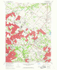
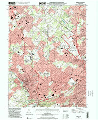
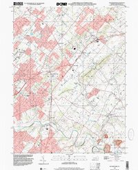
 1992 Doylestown1995 Print · USGSBucks County at the start of the nineties reveals a landscape of growing towns and preserved open spaces along the Neshaminy Creek. Trace the footprints of historical communities like New Britain and Chalfont, or locate local landmarks like Beulah Chapel and the Warrington Airfield.
 - 1999 Map of Doylestown, 2001 Print
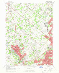
 1999 Doylestown2001 Print · USGSBucks County at the close of the century shows a landscape where historic crossroads like Doylestown meet modern infrastructure. Researchers can trace local landmarks such as the County Home, Beulah Cem Chapel, and the Peace Valley Reservoir.
 - 1999 Map of Hatboro, 2001 Print
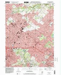 1999 Hatboro2001 Print · USGSThe suburbs of Montgomery and Bucks counties are shown here at the close of the twentieth century as residential growth reached its peak. Researchers can trace the development of Bryn Athyn and Hatboro or locate local landmarks like Union Cem and Neshaminy Creek.
 - 1999 Map of Ambler, 2001 Print
 1999 Ambler2001 Print · USGSThe Montgomery County suburbs near the turn of the millennium show a landscape of high-density growth and institutional development. Trace local history through anchors like Ambler, the Graeme Historical Site, and the Willow Grove Naval Air Station.
 - 1999 Map of Buckingham, 2001 Print
 1999 Buckingham2001 Print · USGSBucks County was undergoing steady suburban change at the end of the millennium, yet its historic township patterns remained clear. Researchers can trace family sites near Lahaska, Furlong, and Wycombe, or find community landmarks like the Mt Gilead Ch and Gardenville Sch.
End of results
Showing maps 1-21 of 21
Top cities near Warrington Township
- Philadelphia historical maps
- Bensalem Township historical maps
- Abington Township historical maps
- Middletown Township historical maps
- Cheltenham Township historical maps
- Norristown historical maps
See more
Top neighborhoods of Warrington Township
Frequently asked questions
- What are the different types of historical maps available for Warrington Township?
- What is the oldest map of Warrington Township?
- Where can I purchase historical maps of Warrington Township for my home or office?
- Where can I download high-res historical maps of Warrington Township?
- Are there historical topographic maps available for Warrington Township?
- Is there historical aerial imagery available for Warrington Township?
- Where are historical maps of Warrington Township sourced from?