Old Maps of Coatesville, Pennsylvania
Explore 25 old maps of Coatesville, spanning from 1904 to today. These high-resolution historic maps reveal how streets, neighborhoods, landmarks, and natural features evolved over time — perfect for genealogy, metal detecting, research, and local history exploration.
What you can do with these maps:
- See how Coatesville changed over time: Compare historical maps to modern-day views to trace roads, homesites, rail lines & more.
- View detailed metadata: Each map includes creators, publishers, year, scale, and archive source.
- Overlay maps with satellite & LiDAR: Visualize the past alongside modern tools to explore terrain & human change.
- Trusted historical sources: Maps sourced from the USGS, Library of Congress, and other archives.
- Access maps your way: View online, download high-res files, or order prints for personal or research use.
Start exploring old maps of Coatesville to uncover forgotten places, hidden landmarks, and the deep history beneath your feet.
Coatesville, PA maps
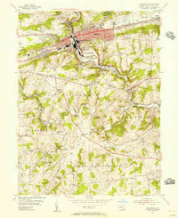
(25)- 1904 Map of Coatesville, 1960 Print
 1904 Coatesville1960 Print · USGSCovers Coatesville, including Caln Township, New Garden Township, and other nearby areas
 - 1905 Map of Honey Brook, 1962 Print
 1905 Honey Brook1962 Print · USGSCovers Coatesville, including Caln Township, East Earl Township, and other nearby areas
 - 1906 Map of Coatesville
 1906 Coatesville1906 Print · USGSCovers Coatesville, including Caln Township, New Garden Township, and other nearby areas8 unique versions available
 - 1907 Map of Honeybrook
 1907 Honeybrook1907 Print · USGSCovers Coatesville, including Caln Township, East Earl Township, and other nearby areas7 unique versions available
 - 1918 Map of Coatesville, 1921 Print
 1918 Coatesville1921 Print · USGSCovers Coatesville, including Caln Township, New Garden Township, and other nearby areas
 - 1941 Map of Honeybrook
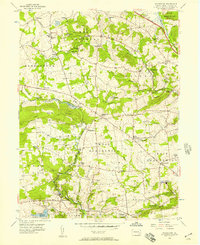
 1941 Honeybrook1941 Print · USGSCovers Coatesville, including Caln Township, East Earl Township, and other nearby areas
 - 1943 Map of Coatesville
 1943 Coatesville1943 Print · USGSCovers Coatesville, including Caln Township, New Garden Township, and other nearby areas
 - 1944 Map of Newark, 1971 Print
 1944 Newark1971 Print · USGSCovers Coatesville, including New York, Philadelphia, and other nearby areas5 unique versions available
 - 1946 Map of Wilmington, 1948 Print
 1946 Wilmington1948 Print · USGSCovers Coatesville, including Philadelphia, Toms River, and other nearby areas2 unique versions available
 - 1949 Map of Newark
 1949 Newark1949 Print · USGSCovers Coatesville, including New York, Philadelphia, and other nearby areas2 unique versions available
 - 1953 Map of Coatesville, 1956 Print
 1953 Coatesville1956 Print · USGSCovers Coatesville, including Caln Township, Thorndale, and other nearby areas6 unique versions available
 - 1955 Map of Wilmington
 1955 Wilmington1955 Print · USGSCovers Coatesville, including Philadelphia, Toms River, and other nearby areas
 - 1956 Map of Newark
 1956 Newark1956 Print · USGSCovers Coatesville, including New York, Philadelphia, and other nearby areas2 unique versions available
 - 1956 Map of Wagontown, 1957 Print
 1956 Wagontown1957 Print · USGSCovers Coatesville, including Caln Township, Wallace Township, and other nearby areas8 unique versions available
 - 1957 Map of Wilmington
 1957 Wilmington1957 Print · USGSCovers Coatesville, including Philadelphia, Toms River, and other nearby areas2 unique versions available
 - 1957 Map of Newark
 1957 Newark1957 Print · USGSCovers Coatesville, including New York, Philadelphia, and other nearby areas
 - 1959 Map of Wilmington
 1959 Wilmington1959 Print · USGSCovers Coatesville, including Philadelphia, Toms River, and other nearby areas3 unique versions available
 - 1960 Map of Newark
 1960 Newark1960 Print · USGSCovers Coatesville, including New York, Philadelphia, and other nearby areas3 unique versions available
 - 1964 Map of Newark
 1964 Newark1964 Print · USGSCovers Coatesville, including New York, Philadelphia, and other nearby areas2 unique versions available
 - 1966 Map of Wilmington, 1968 Print
 1966 Wilmington1968 Print · USGSCovers Coatesville, including Philadelphia, Toms River, and other nearby areas4 unique versions available
 - 1972 Map of Wilmington, 1976 Print
 1972 Wilmington1976 Print · USGSCovers Coatesville, including Philadelphia, Toms River, and other nearby areas2 unique versions available
 - 1984 Map of Wilmington, 1986 Print
 1984 Wilmington1986 Print · USGSCovers Coatesville, including Philadelphia, Upper Darby, and other nearby areas2 unique versions available
 - 1984 Map of Reading, 1986 Print
 1984 Reading1986 Print · USGSCovers Coatesville, including Philadelphia, Reading, and other nearby areas2 unique versions available
 - 1997 Map of Coatesville, 1999 Print
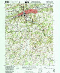 1997 Coatesville1999 Print · USGSCovers Coatesville, including Caln Township, Thorndale, and other nearby areas
 - 1999 Map of Wagontown, 2001 Print
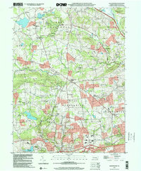 1999 Wagontown2001 Print · USGSCovers Coatesville, including Caln Township, Wallace Township, and other nearby areas
End of results
Showing maps 1-25 of 25
Top cities near Coatesville
- West Goshen Township historical maps
- West Chester historical maps
- Hockessin historical maps
- Caln Township historical maps
- New Garden Township historical maps
- Downingtown historical maps
See more
Frequently asked questions
- What are the different types of historical maps available for Coatesville?
- What is the oldest map of Coatesville?
- Where can I purchase historical maps of Coatesville for my home or office?
- Where can I download high-res historical maps of Coatesville?
- Are there historical topographic maps available for Coatesville?
- Is there historical aerial imagery available for Coatesville?
- Where are historical maps of Coatesville sourced from?