Old Maps of DuBois, Pennsylvania
Explore 14 old maps of DuBois, spanning from 1922 to today. These high-resolution historic maps reveal how streets, neighborhoods, landmarks, and natural features evolved over time — perfect for genealogy, metal detecting, research, and local history exploration.
What you can do with these maps:
- See how DuBois changed over time: Compare historical maps to modern-day views to trace roads, homesites, rail lines & more.
- View detailed metadata: Each map includes creators, publishers, year, scale, and archive source.
- Overlay maps with satellite & LiDAR: Visualize the past alongside modern tools to explore terrain & human change.
- Trusted historical sources: Maps sourced from the USGS, Library of Congress, and other archives.
- Access maps your way: View online, download high-res files, or order prints for personal or research use.
Start exploring old maps of DuBois to uncover forgotten places, hidden landmarks, and the deep history beneath your feet.
DuBois, PA maps
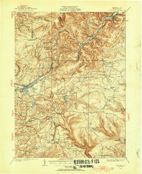
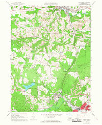
(14)- 1922 Map of Du Bois, 1957 Print
 1922 Du Bois1957 Print · USGSCovers DuBois, including Sandy Township, Reynoldsville, and other nearby areas2 unique versions available
 - 1924 Map of Du Bois
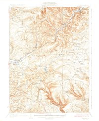
 1924 Du Bois1924 Print · USGSCovers DuBois, including Sandy Township, Reynoldsville, and other nearby areas5 unique versions available
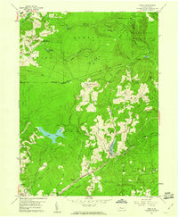
 - 1929 Map of Penfield, 1954 Print
 1929 Penfield1954 Print · USGSCovers DuBois, including Sandy Township, Pine Township, and other nearby areas3 unique versions available
 - 1932 Map of Penfield
 1932 Penfield1932 Print · USGSCovers DuBois, including Sandy Township, Pine Township, and other nearby areas3 unique versions available
 - 1944 Map of Du Bois
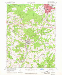
 1944 Du Bois1944 Print · USGSCovers DuBois, including Sandy Township, Reynoldsville, and other nearby areas
 - 1957 Map of Warren, 1964 Print
 1957 Warren1964 Print · USGSCovers DuBois, including Saint Marys, Sandy Township, and other nearby areas4 unique versions available
 - 1958 Map of Warren
 1958 Warren1958 Print · USGSCovers DuBois, including Saint Marys, Sandy Township, and other nearby areas
 - 1959 Map of Warren
 1959 Warren1959 Print · USGSCovers DuBois, including Saint Marys, Sandy Township, and other nearby areas2 unique versions available
 - 1959 Map of Luthersburg, 1960 Print
 1959 Luthersburg1960 Print · USGSCovers DuBois, including Sandy Township, Luthersburg, and other nearby areas5 unique versions available
 - 1959 Map of Sabula, 1960 Print
 1959 Sabula1960 Print · USGSCovers DuBois, including Sandy Township, Snyder Township, and other nearby areas7 unique versions available
 - 1966 Map of Falls Creek, 1968 Print
 1966 Falls Creek1968 Print · USGSCovers DuBois, including Sandy Township, Brockway, and other nearby areas5 unique versions available
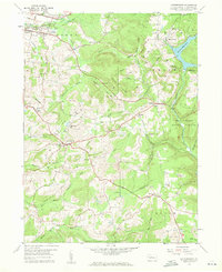
 - 1966 Map of Du Bois, 1968 Print
 1966 Du Bois1968 Print · USGSCovers DuBois, including Sandy Township, Sykesville, and other nearby areas6 unique versions available
 - 1971 Map of Warren
 1971 Warren1971 Print · USGSCovers DuBois, including Saint Marys, Sandy Township, and other nearby areas
 - 1983 Map of Clearfield, 1984 Print
 1983 Clearfield1984 Print · USGSCovers DuBois, including Saint Marys, Sandy Township, and other nearby areas
End of results
Showing maps 1-14 of 14
Top cities near DuBois
- Sandy Township historical maps
- Punxsutawney historical maps
- Winslow historical maps
- Reynoldsville historical maps
- Brockway historical maps
- Warsaw Township historical maps
See more
Frequently asked questions
- What are the different types of historical maps available for DuBois?
- What is the oldest map of DuBois?
- Where can I purchase historical maps of DuBois for my home or office?
- Where can I download high-res historical maps of DuBois?
- Are there historical topographic maps available for DuBois?
- Is there historical aerial imagery available for DuBois?
- Where are historical maps of DuBois sourced from?