1990s Maps of Camp Hill, Cumberland County
Explore 2 historic maps of Camp Hill from the 1990s. These maps offer a rare glimpse into what life looked like during the 1990s — showing old roads, neighborhoods, homes, and landmarks that have changed or disappeared over time.
Whether you're researching your family's past, planning a metal detecting trip, or studying how Camp Hill's landscape evolved across the 1990s, these high-resolution maps are a powerful tool for exploring the history of this region.
- Focus on a specific era: All maps on this page are from the 1990s, giving you a focused view of this time period.
- See what’s changed: Compare century-old streets, trails, and buildings to today's modern landscape using overlays and satellite layers.
- Research with precision: Use these maps for genealogy, historical research, land use analysis, or educational projects.
- View, download, or print: Maps are fully viewable online in high resolution, and can be downloaded or printed for your own records.
Start exploring Camp Hill's history through authentic maps from the 1990s. This is your window into the past.
Camp Hill, Cumberland County maps
(2)- 1993 Map of Harrisburg West, 1999 Print
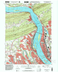 1993 Harrisburg West1999 Print · USGSThe Susquehanna River valley in the early 1990s shows a landscape defined by massive rail infrastructure and urban expansion. Genealogists and historians can trace family roots through Enola and Wormleysburg or locate historic sites like Good Hope Mill and the Rockville Bridge.
 - 1999 Map of Lemoyne, 2001 Print
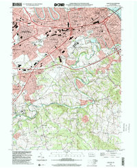 1999 Lemoyne2001 Print · USGSThe West Shore communities and the Susquehanna River are captured here at the end of the century. Trace the evolution of historic settlements like Shiremanstown and Eberlys Mill, or locate family sites at Lantz Cem and Messiah College.
End of results
Showing maps 1-2 of 2
Frequently asked questions
- What are the different types of historical maps available for Camp Hill?
- What is the oldest map of Camp Hill?
- Where can I purchase historical maps of Camp Hill for my home or office?
- Where can I download high-res historical maps of Camp Hill?
- Are there historical topographic maps available for Camp Hill?
- Is there historical aerial imagery available for Camp Hill?
- Where are historical maps of Camp Hill sourced from?