1990s Maps of Bethel Township, Pennsylvania
Explore 3 historic maps of Bethel Township from the 1990s. These maps offer a rare glimpse into what life looked like during the 1990s — showing old roads, neighborhoods, homes, and landmarks that have changed or disappeared over time.
Whether you're researching your family's past, planning a metal detecting trip, or studying how Bethel Township's landscape evolved across the 1990s, these high-resolution maps are a powerful tool for exploring the history of this region.
- Focus on a specific era: All maps on this page are from the 1990s, giving you a focused view of this time period.
- See what’s changed: Compare century-old streets, trails, and buildings to today's modern landscape using overlays and satellite layers.
- Research with precision: Use these maps for genealogy, historical research, land use analysis, or educational projects.
- View, download, or print: Maps are fully viewable online in high resolution, and can be downloaded or printed for your own records.
Start exploring Bethel Township's history through authentic maps from the 1990s. This is your window into the past.
Bethel Township, PA maps
(3)- 1994 Map of Amaranth, 1997 Print
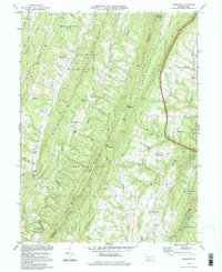 1994 Amaranth1997 Print · USGSThe ridge-and-valley country of the Pennsylvania borderlands remained a mosaic of state forests and small hamlets in the 1990s. Genealogists can locate family landmarks like Silver Mills and Lashley, or trace ancestral ties to Bethel Ch and Jerusalem Ch.
 - 1996 Map of Bellegrove, 1999 Print
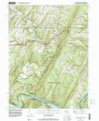 1996 Bellegrove1999 Print · USGSThe tri-state border region of Maryland, Pennsylvania, and West Virginia is mapped here during the late nineties. Researchers can trace the winding Sideling Hill Creek and locate historic points like St Pauls Ch and the riverside tracks of CSX Transportation.
 - 1996 Map of Hancock, 2000 Print
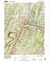 1996 Hancock2000 Print · USGSThe tri-state border region comes alive in the late nineties as transportation corridors follow the winding river gaps through the Appalachian ridges. Trace local landmarks from the Mason and Dixon Line down to Berkeley Springs, including Stotlers Crossroads and the Potomac Airport.
End of results
Showing maps 1-3 of 3
Top cities near Bethel Township
- Everett historical maps
- Hancock historical maps
- McConnellsburg historical maps
- Berkeley Springs historical maps
- Little Orleans historical maps
Top neighborhoods of Bethel Township
Frequently asked questions
- What are the different types of historical maps available for Bethel Township?
- What is the oldest map of Bethel Township?
- Where can I purchase historical maps of Bethel Township for my home or office?
- Where can I download high-res historical maps of Bethel Township?
- Are there historical topographic maps available for Bethel Township?
- Is there historical aerial imagery available for Bethel Township?
- Where are historical maps of Bethel Township sourced from?