1960s Maps of Franklin Township, Pennsylvania
Explore 6 historic maps of Franklin Township from the 1960s. These maps offer a rare glimpse into what life looked like during the 1960s — showing old roads, neighborhoods, homes, and landmarks that have changed or disappeared over time.
Whether you're researching your family's past, planning a metal detecting trip, or studying how Franklin Township's landscape evolved across the 1960s, these high-resolution maps are a powerful tool for exploring the history of this region.
- Focus on a specific era: All maps on this page are from the 1960s, giving you a focused view of this time period.
- See what’s changed: Compare century-old streets, trails, and buildings to today's modern landscape using overlays and satellite layers.
- Research with precision: Use these maps for genealogy, historical research, land use analysis, or educational projects.
- View, download, or print: Maps are fully viewable online in high resolution, and can be downloaded or printed for your own records.
Start exploring Franklin Township's history through authentic maps from the 1960s. This is your window into the past.
Franklin Township, PA maps
(6)- 1961 Map of Clarksburg
 1961 Clarksburg1961 Print · USGSThe mid-century industrial and river landscapes of West Virginia and Ohio are detailed here, centered on the Ohio River. Researchers can trace the Baltimore and Ohio rail lines connecting towns like Parkersburg, Clarksburg, and Monongah.
 - 1961 Map of Oak Forest, 1963 Print
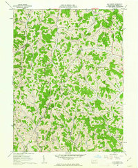 1961 Oak Forest1963 Print · USGSGreene County’s rural character is captured here in the early 1960s, showing a landscape of hollows and ridge-top settlements. Genealogists can trace family landmarks and rural hubs like Oak Forest, Spraggs, and the Shannon Run Sch.4 unique versions available
 - 1961 Map of Waynesburg, 1963 Print
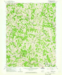
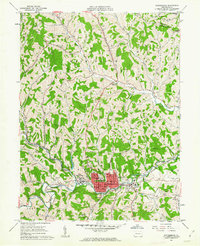 1961 Waynesburg1963 Print · USGSMid-century Greene County comes to life in this detailed survey centered on the collegiate town of Waynesburg. Researchers can locate family sites at Green Mount Cem, trace the local coal landscape at Grimes Portal, or find the old Drive-in Theater.4 unique versions available
 - 1961 Map of Garards Fort, 1963 Print
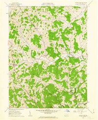 1961 Garards Fort1963 Print · USGSGreene County in the early sixties remains a patchwork of family cemeteries and coal shafts. Genealogists can trace ancestral sites like Morris Cem or the Asbury Ch, while others can find the exact locations of the Garards Fort Shaft and old Covered Bridge.4 unique versions available
 - 1961 Map of Mather, 1963 Print
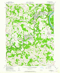 1961 Mather1963 Print · USGSThe industrial coal and river economy of Greene County is on full display in the early 1960s. Researchers can trace the layout of mining-era housing like Braden Plan, locate the Emerald Mine, or find ancestors at Pollock Cem and Mt Zion Cem & Ch.3 unique versions available
 - 1964 Map of Rogersville, 1965 Print
 1964 Rogersville1965 Print · USGSGreene County entered the mid-sixties with a landscape defined by its deep creek valleys and a growing network of gas and oil infrastructure. Researchers can locate dozens of Gas Wells, the historic Covered Bridge, and community anchors like Nineveh and Beulah Ch.4 unique versions available
End of results
Showing maps 1-6 of 6
Top cities near Franklin Township
- Morgantown historical maps
- Luzerne Township historical maps
- Waynesburg historical maps
- Centerville historical maps
- Bentleyville historical maps
- Dunkard Township historical maps
See more
Top neighborhoods of Franklin Township
- West Waynesburg historical maps
- East View historical maps
- Brant Hill historical maps
- Blairtown historical maps
- Morrisville historical maps
- Rees Mill historical maps
Frequently asked questions
- What are the different types of historical maps available for Franklin Township?
- What is the oldest map of Franklin Township?
- Where can I purchase historical maps of Franklin Township for my home or office?
- Where can I download high-res historical maps of Franklin Township?
- Are there historical topographic maps available for Franklin Township?
- Is there historical aerial imagery available for Franklin Township?
- Where are historical maps of Franklin Township sourced from?