1920s Maps of Huntingdon, Pennsylvania
Explore 4 historic maps of Huntingdon from the 1920s. These maps offer a rare glimpse into what life looked like during the 1920s — showing old roads, neighborhoods, homes, and landmarks that have changed or disappeared over time.
Whether you're researching your family's past, planning a metal detecting trip, or studying how Huntingdon's landscape evolved across the 1920s, these high-resolution maps are a powerful tool for exploring the history of this region.
- Focus on a specific era: All maps on this page are from the 1920s, giving you a focused view of this time period.
- See what’s changed: Compare century-old streets, trails, and buildings to today's modern landscape using overlays and satellite layers.
- Research with precision: Use these maps for genealogy, historical research, land use analysis, or educational projects.
- View, download, or print: Maps are fully viewable online in high resolution, and can be downloaded or printed for your own records.
Start exploring Huntingdon's history through authentic maps from the 1920s. This is your window into the past.
Huntingdon, PA maps
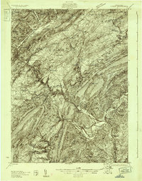
(4)- 1922 Map of Mt Union
 1922 Mt Union1922 Print · USGSThe Juniata River valley in the early 1920s reveals a landscape shaped by the Pennsylvania RR and early motor routes like the Lincoln Highway. Genealogists can trace dozens of rural schoolhouses and vanished post offices, including Red Fork PO, Shirleysburg, and Lucy Furnace School.2 unique versions available
 - 1923 Map of Tyrone
 1923 Tyrone1923 Print · USGSThe industrial and rail corridor of the Juniata Valley is captured here in the early twenties as it winds between massive ridges. Researchers can locate early iron landmarks like Huntingdon Furnace, local schools such as Kinch School, and the rail junction at Tyrone.4 unique versions available
 - 1924 Map of Mt. Union
 1924 Mt. Union1924 Print · USGSMount Union and the central Juniata River valley are shown here in the mid-twenties as the rail-and-river economy flourished. Genealogists can locate dozens of named rural schools like Smoke School and old post offices such as Shade Valley P.O.4 unique versions available
 - 1929 Map of Tyrone
 1929 Tyrone1929 Print · USGSCentral Pennsylvania during the 1920s reveals a landscape defined by industrial rail towns and limestone valleys. Trace the route of the Pennsylvania Railroad past historic sites like Graziers Mill and Union Furnace.6 unique versions available
End of results
Showing maps 1-4 of 4
Top cities near Huntingdon
- Tyrone historical maps
- Mount Union historical maps
- Menno Township historical maps
- Warriors Mark Township historical maps
- Williamsburg historical maps
- Todd Township historical maps
See more
Top neighborhoods of Huntingdon
Frequently asked questions
- What are the different types of historical maps available for Huntingdon?
- What is the oldest map of Huntingdon?
- Where can I purchase historical maps of Huntingdon for my home or office?
- Where can I download high-res historical maps of Huntingdon?
- Are there historical topographic maps available for Huntingdon?
- Is there historical aerial imagery available for Huntingdon?
- Where are historical maps of Huntingdon sourced from?