Old Maps of Brockway, Jefferson County for Genealogy
Trace your family roots with 12 historic maps of Brockway. These high-res maps reveal old neighborhoods, homesites, landmarks, and streets — helping you uncover where your ancestors lived and how the area evolved over time.
- Explore historic neighborhoods: Identify where your relatives may have lived in the 1800s or 1900s.
- Compare maps over time: Trace the changes in streets, buildings, and landmarks for multi-generational research.
- Perfect for genealogy & ancestry research: Used by family historians and researchers to map out lineage and migration.
These maps are an incredible resource for exploring your personal connection to Brockway's past.
Brockway, Jefferson County maps
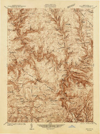
(12)- 1922 Map of Du Bois, 1957 Print
 1922 Du Bois1957 Print · USGSCovers Brockway, including Sandy Township, DuBois, and other nearby areas2 unique versions available
 - 1924 Map of Du Bois
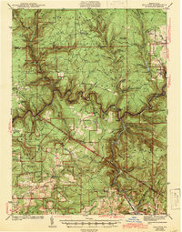
 1924 Du Bois1924 Print · USGSCovers Brockway, including Sandy Township, DuBois, and other nearby areas5 unique versions available
 - 1940 Map of Hallton
 1940 Hallton1940 Print · USGSCovers Brockway, including Warsaw Township, Millstone Township, and other nearby areas3 unique versions available
 - 1943 Map of Hallton
 1943 Hallton1943 Print · USGSCovers Brockway, including Warsaw Township, Millstone Township, and other nearby areas3 unique versions available
 - 1944 Map of Du Bois
 1944 Du Bois1944 Print · USGSCovers Brockway, including Sandy Township, DuBois, and other nearby areas
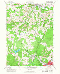
 - 1957 Map of Warren, 1964 Print
 1957 Warren1964 Print · USGSCovers Brockway, including Saint Marys, Sandy Township, and other nearby areas4 unique versions available
 - 1958 Map of Warren
 1958 Warren1958 Print · USGSCovers Brockway, including Saint Marys, Sandy Township, and other nearby areas
 - 1959 Map of Warren
 1959 Warren1959 Print · USGSCovers Brockway, including Saint Marys, Sandy Township, and other nearby areas2 unique versions available
 - 1966 Map of Falls Creek, 1968 Print
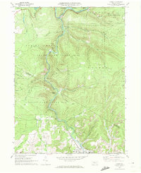
 1966 Falls Creek1968 Print · USGSCovers Brockway, including Sandy Township, DuBois, and other nearby areas5 unique versions available
 - 1970 Map of Carman, 1972 Print
 1970 Carman1972 Print · USGSCovers Brockway, including Polk Township, Snyder Township, and other nearby areas3 unique versions available
 - 1971 Map of Warren
 1971 Warren1971 Print · USGSCovers Brockway, including Saint Marys, Sandy Township, and other nearby areas
 - 1983 Map of Clearfield, 1984 Print
 1983 Clearfield1984 Print · USGSCovers Brockway, including Saint Marys, Sandy Township, and other nearby areas
End of results
Showing maps 1-12 of 12
Frequently asked questions
- What are the different types of historical maps available for Brockway?
- What is the oldest map of Brockway?
- Where can I purchase historical maps of Brockway for my home or office?
- Where can I download high-res historical maps of Brockway?
- Are there historical topographic maps available for Brockway?
- Is there historical aerial imagery available for Brockway?
- Where are historical maps of Brockway sourced from?