1960s Maps of Iowa, Pine Creek Township
Explore 1 historic maps of Iowa from the 1960s. These maps offer a rare glimpse into what life looked like during the 1960s — showing old roads, neighborhoods, homes, and landmarks that have changed or disappeared over time.
Whether you're researching your family's past, planning a metal detecting trip, or studying how Iowa's landscape evolved across the 1960s, these high-resolution maps are a powerful tool for exploring the history of this region.
- Focus on a specific era: All maps on this page are from the 1960s, giving you a focused view of this time period.
- See what’s changed: Compare century-old streets, trails, and buildings to today's modern landscape using overlays and satellite layers.
- Research with precision: Use these maps for genealogy, historical research, land use analysis, or educational projects.
- View, download, or print: Maps are fully viewable online in high resolution, and can be downloaded or printed for your own records.
Start exploring Iowa's history through authentic maps from the 1960s. This is your window into the past.
Iowa, Pine Creek Township maps
(1)- 1969 Map of Coolspring, 1972 Print
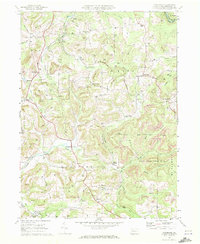 1969 Coolspring1972 Print · USGSJefferson County was a hub of resource extraction and rail activity in the late sixties. Genealogists and historians can trace the locations of family burial grounds and country parishes such as St Johns Cem, Hunters Grove Ch, and Stanton.5 unique versions available
End of results
Showing maps 1-1 of 1
Top cities near Iowa
- Sandy Township historical maps
- DuBois historical maps
- Punxsutawney historical maps
- Brookville historical maps
- Winslow historical maps
- Reynoldsville historical maps
See more
Frequently asked questions
- What are the different types of historical maps available for Iowa?
- What is the oldest map of Iowa?
- Where can I purchase historical maps of Iowa for my home or office?
- Where can I download high-res historical maps of Iowa?
- Are there historical topographic maps available for Iowa?
- Is there historical aerial imagery available for Iowa?
- Where are historical maps of Iowa sourced from?