1960s Maps of Mahoning Township, Pennsylvania
Explore 4 historic maps of Mahoning Township from the 1960s. These maps offer a rare glimpse into what life looked like during the 1960s — showing old roads, neighborhoods, homes, and landmarks that have changed or disappeared over time.
Whether you're researching your family's past, planning a metal detecting trip, or studying how Mahoning Township's landscape evolved across the 1960s, these high-resolution maps are a powerful tool for exploring the history of this region.
- Focus on a specific era: All maps on this page are from the 1960s, giving you a focused view of this time period.
- See what’s changed: Compare century-old streets, trails, and buildings to today's modern landscape using overlays and satellite layers.
- Research with precision: Use these maps for genealogy, historical research, land use analysis, or educational projects.
- View, download, or print: Maps are fully viewable online in high resolution, and can be downloaded or printed for your own records.
Start exploring Mahoning Township's history through authentic maps from the 1960s. This is your window into the past.
Mahoning Township, PA maps
(4)- 1962 Map of Canton
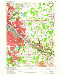
 1962 Canton1962 Print · USGSThe industrial heartland of Eastern Ohio and Western Pennsylvania thrives in the early sixties as steel mills and rail lines dominate the river valleys. Genealogists and historians can trace local landmarks like McKinley National Memorial, Malone College, and industrial sites such as Republic Steel Corp.2 unique versions available
 - 1962 Map of Cleveland
 1962 Cleveland1962 Print · USGSNortheast Ohio and the Pennsylvania borderlands appear here during the industrial peak of the early sixties. Genealogists and historians can trace the expansive rail lines of the Nickel Plate Road and the growth of suburbs from Parma to Lyndhurst.
 - 1963 Map of Campbell, 1964 Print
 1963 Campbell1964 Print · USGSThe Mahoning Valley industrial corridor reached a peak of rail and steel development during the early sixties. Genealogists can trace family roots through neighborhood landmarks like Scienceville, the Poland Cemetery, and many local schools from Reed Sch to Haddow Sch.3 unique versions available
 - 1963 Map of New Middletown, 1964 Print
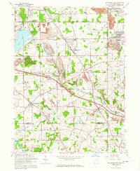 1963 New Middletown1964 Print · USGSThe Mahoning County borderlands come into focus in the early sixties as major turnpikes began to reshape the rural landscape. Researchers can find family-named landmarks and essential community sites like Zion Cem, Bethel Ch, and Springfield Township High Sch.3 unique versions available
End of results
Showing maps 1-4 of 4
Top cities near Mahoning Township
- Youngstown historical maps
- Boardman historical maps
- New Castle historical maps
- Hermitage historical maps
- Sharon historical maps
- Unity historical maps
See more
Top neighborhoods of Mahoning Township
- Hillsville historical maps
- Peanut historical maps
- Robinson historical maps
- Edinburg historical maps
- North Edinburg historical maps
Frequently asked questions
- What are the different types of historical maps available for Mahoning Township?
- What is the oldest map of Mahoning Township?
- Where can I purchase historical maps of Mahoning Township for my home or office?
- Where can I download high-res historical maps of Mahoning Township?
- Are there historical topographic maps available for Mahoning Township?
- Is there historical aerial imagery available for Mahoning Township?
- Where are historical maps of Mahoning Township sourced from?