1990s Maps of North Lebanon Township, Pennsylvania
Explore 3 historic maps of North Lebanon Township from the 1990s. These maps offer a rare glimpse into what life looked like during the 1990s — showing old roads, neighborhoods, homes, and landmarks that have changed or disappeared over time.
Whether you're researching your family's past, planning a metal detecting trip, or studying how North Lebanon Township's landscape evolved across the 1990s, these high-resolution maps are a powerful tool for exploring the history of this region.
- Focus on a specific era: All maps on this page are from the 1990s, giving you a focused view of this time period.
- See what’s changed: Compare century-old streets, trails, and buildings to today's modern landscape using overlays and satellite layers.
- Research with precision: Use these maps for genealogy, historical research, land use analysis, or educational projects.
- View, download, or print: Maps are fully viewable online in high resolution, and can be downloaded or printed for your own records.
Start exploring North Lebanon Township's history through authentic maps from the 1990s. This is your window into the past.
North Lebanon Township, PA maps
(3)- 1992 Map of Bethel, 1995 Print
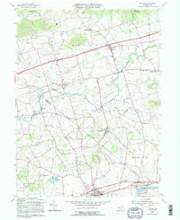 1992 Bethel1995 Print · USGSThe Berks and Lebanon county line area comes to life in this detailed late-century survey of rural Pennsylvania townships. Genealogists and historians can trace family-named sites like Merkey Ch, the historic Union Canal, and the old mills at Crosskill Mills.
 - 1995 Map of Lebanon, 1996 Print
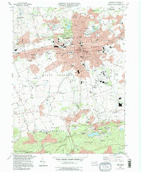 1995 Lebanon1996 Print · USGSThe Lebanon area in the mid-nineties reveals a landscape shaped by iron mining and sprawling residential growth. Researchers can trace historic industrial roots at the Cornwall Iron Furnace or find ancestral sites like Kimmerlings Ch and Burd Coleman Village.
 - 1999 Map of Fredericksburg, 2001 Print
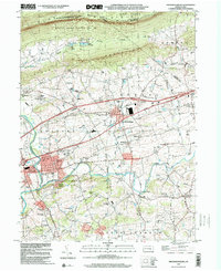 1999 Fredericksburg2001 Print · USGSThe northern Lebanon County valley was a landscape of small farms and wooded ridges at the turn of the millennium. Researchers can trace the development of local hamlets and rural schoolhouses like Shirksville, West Jonestown, and the Umberger Sch.
End of results
Showing maps 1-3 of 3
Top cities near North Lebanon Township
- Lebanon historical maps
- Hershey historical maps
- Ephrata historical maps
- Elizabethtown historical maps
- Lititz historical maps
- Palmyra historical maps
See more
Top neighborhoods of North Lebanon Township
- Rockwood historical maps
- Pansy Hill historical maps
- Sand Hill historical maps
- Sunset historical maps
- Westmont historical maps
- Ebenezer historical maps
See more
Frequently asked questions
- What are the different types of historical maps available for North Lebanon Township?
- What is the oldest map of North Lebanon Township?
- Where can I purchase historical maps of North Lebanon Township for my home or office?
- Where can I download high-res historical maps of North Lebanon Township?
- Are there historical topographic maps available for North Lebanon Township?
- Is there historical aerial imagery available for North Lebanon Township?
- Where are historical maps of North Lebanon Township sourced from?