1950s Maps of South Lebanon Township, Pennsylvania
Explore 6 historic maps of South Lebanon Township from the 1950s. These maps offer a rare glimpse into what life looked like during the 1950s — showing old roads, neighborhoods, homes, and landmarks that have changed or disappeared over time.
Whether you're researching your family's past, planning a metal detecting trip, or studying how South Lebanon Township's landscape evolved across the 1950s, these high-resolution maps are a powerful tool for exploring the history of this region.
- Focus on a specific era: All maps on this page are from the 1950s, giving you a focused view of this time period.
- See what’s changed: Compare century-old streets, trails, and buildings to today's modern landscape using overlays and satellite layers.
- Research with precision: Use these maps for genealogy, historical research, land use analysis, or educational projects.
- View, download, or print: Maps are fully viewable online in high resolution, and can be downloaded or printed for your own records.
Start exploring South Lebanon Township's history through authentic maps from the 1950s. This is your window into the past.
South Lebanon Township, PA maps
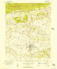
(6)- 1950 Map of Harrisburg, 1952 Print
 1950 Harrisburg1952 Print · USGSMid-century Central Pennsylvania comes alive through its dense rail networks and river valley settlements during the post-war industrial era. Genealogists and historians can trace family roots through hubs like Harrisburg, locate Carlisle Barracks, or follow the Pennsylvania RR through the Lebanon Valley.
 - 1955 Map of Richland, 1956 Print
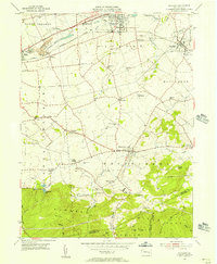 1955 Richland1956 Print · USGSThe Lebanon Valley was a bustling corridor of rail and old canal beds in the mid-fifties. Genealogists can trace family roots through numerous country landmarks like Heidelberg Ch, Kralls Ch, and the many rural schools and cemeteries scattered near Schaefferstown.6 unique versions available
 - 1955 Map of Lebanon, 1956 Print
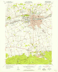 1955 Lebanon1956 Print · USGSMid-century Lebanon and its surrounding furnace villages are detailed in this survey of a shifting industrial landscape. Genealogists can locate family landmarks like Kimmerlings Ch, Zinns Mill, and the Union Canal (Abnd).6 unique versions available
 - 1955 Map of Manheim, 1957 Print
 1955 Manheim1957 Print · USGSMid-century Lancaster County life centers on the borough of Manheim as the local rail and road networks reached their peak. Trace family history through numerous rural landmarks like Gantzs Ch, Mastersonville, and the Shoemaker Cem burial grounds.6 unique versions available
 - 1956 Map of Lititz, 1957 Print
 1956 Lititz1957 Print · USGSMid-century Lancaster County comes to life as the industrial borough of Lititz thrives alongside its rural neighbors. Genealogists and researchers can trace local families through many landmarks like Linden Hall Sch, Erbs Ch, and the crossroads of Brickerville.5 unique versions available
 - 1957 Map of Harrisburg
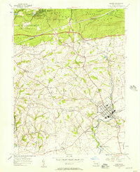
 1957 Harrisburg1957 Print · USGSMid-century Central Pennsylvania comes into focus as a bustling network of rail, river, and mountain ridges. Genealogists and historians can trace the development of the State Capitol and surrounding hubs like Middletown, Columbia, and Pottsville.7 unique versions available
End of results
Showing maps 1-6 of 6
Top cities near South Lebanon Township
- Lebanon historical maps
- Hershey historical maps
- Ephrata historical maps
- Elizabethtown historical maps
- Lititz historical maps
- Mount Joy historical maps
See more
Top neighborhoods of South Lebanon Township
- Avon historical maps
- Midway historical maps
- Iona historical maps
- Prescott historical maps
- Edisonville historical maps
- Lebanon South historical maps
Frequently asked questions
- What are the different types of historical maps available for South Lebanon Township?
- What is the oldest map of South Lebanon Township?
- Where can I purchase historical maps of South Lebanon Township for my home or office?
- Where can I download high-res historical maps of South Lebanon Township?
- Are there historical topographic maps available for South Lebanon Township?
- Is there historical aerial imagery available for South Lebanon Township?
- Where are historical maps of South Lebanon Township sourced from?