Old Maps of Laurel Run, Luzerne County for Genealogy
Trace your family roots with 17 historic maps of Laurel Run. These high-res maps reveal old neighborhoods, homesites, landmarks, and streets — helping you uncover where your ancestors lived and how the area evolved over time.
- Explore historic neighborhoods: Identify where your relatives may have lived in the 1800s or 1900s.
- Compare maps over time: Trace the changes in streets, buildings, and landmarks for multi-generational research.
- Perfect for genealogy & ancestry research: Used by family historians and researchers to map out lineage and migration.
These maps are an incredible resource for exploring your personal connection to Laurel Run's past.
Laurel Run, Luzerne County maps
(17)- 1891 Map of Wilkesbarre
 1891 Wilkesbarre1891 Print · USGSCovers Laurel Run, including Wilkes-Barre, Nanticoke, and other nearby areas2 unique versions available
 - 1894 Map of Wilkesbarre
 1894 Wilkesbarre1894 Print · USGSCovers Laurel Run, including Wilkes-Barre, Nanticoke, and other nearby areas8 unique versions available
 - 1943 Map of Scranton
 1943 Scranton1943 Print · USGSCovers Laurel Run, including Scranton, Wilkes-Barre, and other nearby areas
 - 1947 Map of Wilkes-Barre West, 1958 Print
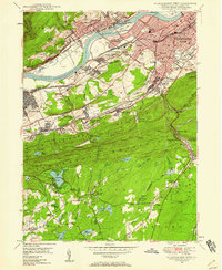 1947 Wilkes-Barre West1958 Print · USGSCovers Laurel Run, including Wilkes-Barre, Nanticoke, and other nearby areas6 unique versions available
 - 1947 Map of Wilkes-Barre East, 1959 Print
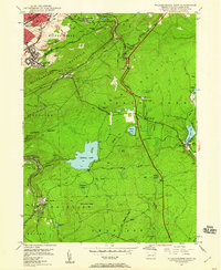 1947 Wilkes-Barre East1959 Print · USGSCovers Laurel Run, including Wilkes-Barre, Plains Township, and other nearby areas7 unique versions available
 - 1950 Map of Wilkes-Barre West
 1950 Wilkes-Barre West1950 Print · USGSCovers Laurel Run, including Wilkes-Barre, Nanticoke, and other nearby areas2 unique versions available
 - 1950 Map of Wilkes-Barre East
 1950 Wilkes-Barre East1950 Print · USGSCovers Laurel Run, including Wilkes-Barre, Plains Township, and other nearby areas2 unique versions available
 - 1950 Map of Scranton, 1952 Print
 1950 Scranton1952 Print · USGSCovers Laurel Run, including Ramapo, Clarkstown, and other nearby areas
 - 1953 Map of Scranton
 1953 Scranton1953 Print · USGSCovers Laurel Run, including Ramapo, Clarkstown, and other nearby areas
 - 1959 Map of Scranton
 1959 Scranton1959 Print · USGSCovers Laurel Run, including Ramapo, Clarkstown, and other nearby areas2 unique versions available
 - 1962 Map of Scranton, 1977 Print
 1962 Scranton1977 Print · USGSCovers Laurel Run, including Ramapo, Clarkstown, and other nearby areas2 unique versions available
 - 1965 Map of Scranton
 1965 Scranton1965 Print · USGSCovers Laurel Run, including Ramapo, Clarkstown, and other nearby areas2 unique versions available
 - 1976 Map of Wilkes-Barre East, 1979 Print
 1976 Wilkes-Barre East1979 Print · USGSCovers Laurel Run, including Wilkes-Barre, Plains Township, and other nearby areas
 - 1976 Map of Wilkes-Barre West, 1979 Print
 1976 Wilkes-Barre West1979 Print · USGSCovers Laurel Run, including Wilkes-Barre, Nanticoke, and other nearby areas
 - 1986 Map of Scranton
 1986 Scranton1986 Print · USGSCovers Laurel Run, including Scranton, Wilkes-Barre, and other nearby areas2 unique versions available
 - 1994 Map of Wilkes-Barre East, 1995 Print
 1994 Wilkes-Barre East1995 Print · USGSCovers Laurel Run, including Wilkes-Barre, Plains Township, and other nearby areas
 - 1999 Map of Wilkes-Barre East, 2002 Print
 1999 Wilkes-Barre East2002 Print · USGSCovers Laurel Run, including Wilkes-Barre, Plains Township, and other nearby areas
End of results
Showing maps 1-17 of 17
Frequently asked questions
- What are the different types of historical maps available for Laurel Run?
- What is the oldest map of Laurel Run?
- Where can I purchase historical maps of Laurel Run for my home or office?
- Where can I download high-res historical maps of Laurel Run?
- Are there historical topographic maps available for Laurel Run?
- Is there historical aerial imagery available for Laurel Run?
- Where are historical maps of Laurel Run sourced from?