1930s Maps of English Mills, Cummings Township
Explore 2 historic maps of English Mills from the 1930s. These maps offer a rare glimpse into what life looked like during the 1930s — showing old roads, neighborhoods, homes, and landmarks that have changed or disappeared over time.
Whether you're researching your family's past, planning a metal detecting trip, or studying how English Mills's landscape evolved across the 1930s, these high-resolution maps are a powerful tool for exploring the history of this region.
- Focus on a specific era: All maps on this page are from the 1930s, giving you a focused view of this time period.
- See what’s changed: Compare century-old streets, trails, and buildings to today's modern landscape using overlays and satellite layers.
- Research with precision: Use these maps for genealogy, historical research, land use analysis, or educational projects.
- View, download, or print: Maps are fully viewable online in high resolution, and can be downloaded or printed for your own records.
Start exploring English Mills's history through authentic maps from the 1930s. This is your window into the past.
English Mills, Cummings Township maps
(2)- 1935 Map of Waterville, 1973 Print
 1935 Waterville1973 Print · USGSLycoming County at the dawn of the 1970s shows a landscape of deep valleys and rising ridges shaped by the Penn Central rail line. Researchers can trace the rural communities of Waterville and Tombs, locating local landmarks like Centennial Ch and Mt Pleasant Ch.
 - 1937 Map of Waterville
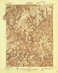 1937 Waterville1937 Print · USGSThe Pine Creek valley and its logging railroad corridors come alive in this late 1930s survey of Lycoming County. Researchers can trace the era of the Civilian Conservation Corps at CCC Camp No 129 or locate family roots at English Center, Cammal, and Okome.5 unique versions available
End of results
Showing maps 1-2 of 2
Top cities near English Mills
- Lock Haven historical maps
- Jersey Shore historical maps
- Avis historical maps
- Flemington historical maps
- Castanea Township historical maps
- Morris Township historical maps
See more
Frequently asked questions
- What are the different types of historical maps available for English Mills?
- What is the oldest map of English Mills?
- Where can I purchase historical maps of English Mills for my home or office?
- Where can I download high-res historical maps of English Mills?
- Are there historical topographic maps available for English Mills?
- Is there historical aerial imagery available for English Mills?
- Where are historical maps of English Mills sourced from?