1940s Maps of Cammal, McHenry Township
Explore 1 historic maps of Cammal from the 1940s. These maps offer a rare glimpse into what life looked like during the 1940s — showing old roads, neighborhoods, homes, and landmarks that have changed or disappeared over time.
Whether you're researching your family's past, planning a metal detecting trip, or studying how Cammal's landscape evolved across the 1940s, these high-resolution maps are a powerful tool for exploring the history of this region.
- Focus on a specific era: All maps on this page are from the 1940s, giving you a focused view of this time period.
- See what’s changed: Compare century-old streets, trails, and buildings to today's modern landscape using overlays and satellite layers.
- Research with precision: Use these maps for genealogy, historical research, land use analysis, or educational projects.
- View, download, or print: Maps are fully viewable online in high resolution, and can be downloaded or printed for your own records.
Start exploring Cammal's history through authentic maps from the 1940s. This is your window into the past.
Cammal, McHenry Township maps
(1)- 1943 Map of Waterville
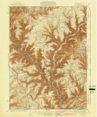 1943 Waterville1943 Print · USGSLycoming County mountain life in the early 1940s centers on the river junctions and rail sidings of the Pine Creek valley. Genealogists and hikers can trace old routes like the Silver Springs Road or find forgotten sites like Ross Siding, Carsontown, and Springer Sch.3 unique versions available
End of results
Showing maps 1-1 of 1
Top cities near Cammal
- Jersey Shore historical maps
- Avis historical maps
- Morris Township historical maps
- Gallagher Township historical maps
- Abbott Township historical maps
- Duncan Township historical maps
Frequently asked questions
- What are the different types of historical maps available for Cammal?
- What is the oldest map of Cammal?
- Where can I purchase historical maps of Cammal for my home or office?
- Where can I download high-res historical maps of Cammal?
- Are there historical topographic maps available for Cammal?
- Is there historical aerial imagery available for Cammal?
- Where are historical maps of Cammal sourced from?