Old Maps of South Williamsport, Lycoming County for Genealogy
Trace your family roots with 17 historic maps of South Williamsport. These high-res maps reveal old neighborhoods, homesites, landmarks, and streets — helping you uncover where your ancestors lived and how the area evolved over time.
- Explore historic neighborhoods: Identify where your relatives may have lived in the 1800s or 1900s.
- Compare maps over time: Trace the changes in streets, buildings, and landmarks for multi-generational research.
- Perfect for genealogy & ancestry research: Used by family historians and researchers to map out lineage and migration.
These maps are an incredible resource for exploring your personal connection to South Williamsport's past.
South Williamsport, Lycoming County maps
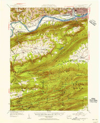
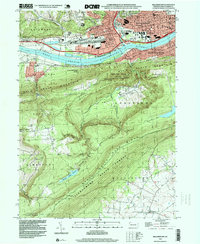
(17)- 1921 Map of Williamsport
 1921 Williamsport1921 Print · USGSCovers South Williamsport, including Williamsport, White Deer Township, and other nearby areas
 - 1923 Map of Williamsport
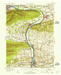
 1923 Williamsport1923 Print · USGSCovers South Williamsport, including Williamsport, White Deer Township, and other nearby areas6 unique versions available
 - 1924 Map of Milton
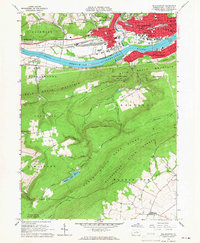
 1924 Milton1924 Print · USGSCovers South Williamsport, including Williamsport, Montoursville, and other nearby areas4 unique versions available
 - 1944 Map of Williamsport
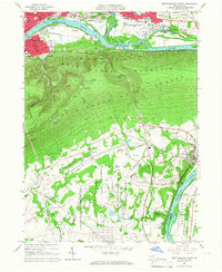
 1944 Williamsport1944 Print · USGSCovers South Williamsport, including Williamsport, White Deer Township, and other nearby areas
 - 1953 Map of Williamsport, 1956 Print
 1953 Williamsport1956 Print · USGSCovers South Williamsport, including Williamsport, White Deer Township, and other nearby areas3 unique versions available
 - 1953 Map of Milton, 1956 Print
 1953 Milton1956 Print · USGSCovers South Williamsport, including Williamsport, Montoursville, and other nearby areas2 unique versions available
 - 1954 Map of Williamsport
 1954 Williamsport1954 Print · USGSCovers South Williamsport, including Vestal, Williamsport, and other nearby areas
 - 1960 Map of Williamsport
 1960 Williamsport1960 Print · USGSCovers South Williamsport, including Vestal, Williamsport, and other nearby areas
 - 1962 Map of Williamsport, 1966 Print
 1962 Williamsport1966 Print · USGSCovers South Williamsport, including Vestal, Williamsport, and other nearby areas5 unique versions available
 - 1965 Map of Williamsport
 1965 Williamsport1965 Print · USGSCovers South Williamsport, including Vestal, Williamsport, and other nearby areas
 - 1965 Map of Williamsport, 1967 Print
 1965 Williamsport1967 Print · USGSCovers South Williamsport, including Williamsport, Garden View, and other nearby areas4 unique versions available
 - 1965 Map of Montoursville South, 1967 Print
 1965 Montoursville South1967 Print · USGSCovers South Williamsport, including Williamsport, Montoursville, and other nearby areas4 unique versions available
 - 1966 Map of Williamsport
 1966 Williamsport1966 Print · USGSCovers South Williamsport, including Vestal, Williamsport, and other nearby areas
 - 1984 Map of Williamsport East, 1985 Print
 1984 Williamsport East1985 Print · USGSCovers South Williamsport, including Williamsport, Bloomsburg, and other nearby areas2 unique versions available
 - 1984 Map of Williamsport West, 1985 Print
 1984 Williamsport West1985 Print · USGSCovers South Williamsport, including Williamsport, Lock Haven, and other nearby areas2 unique versions available
 - 1994 Map of Montoursville South, 1996 Print
 1994 Montoursville South1996 Print · USGSCovers South Williamsport, including Williamsport, Montoursville, and other nearby areas
 - 1994 Map of Williamsport, 1999 Print
 1994 Williamsport1999 Print · USGSCovers South Williamsport, including Williamsport, Garden View, and other nearby areas
End of results
Showing maps 1-17 of 17
Frequently asked questions
- What are the different types of historical maps available for South Williamsport?
- What is the oldest map of South Williamsport?
- Where can I purchase historical maps of South Williamsport for my home or office?
- Where can I download high-res historical maps of South Williamsport?
- Are there historical topographic maps available for South Williamsport?
- Is there historical aerial imagery available for South Williamsport?
- Where are historical maps of South Williamsport sourced from?