1960s Maps of Cartwrights Crossing, Wetmore Township
Explore 1 historic maps of Cartwrights Crossing from the 1960s. These maps offer a rare glimpse into what life looked like during the 1960s — showing old roads, neighborhoods, homes, and landmarks that have changed or disappeared over time.
Whether you're researching your family's past, planning a metal detecting trip, or studying how Cartwrights Crossing's landscape evolved across the 1960s, these high-resolution maps are a powerful tool for exploring the history of this region.
- Focus on a specific era: All maps on this page are from the 1960s, giving you a focused view of this time period.
- See what’s changed: Compare century-old streets, trails, and buildings to today's modern landscape using overlays and satellite layers.
- Research with precision: Use these maps for genealogy, historical research, land use analysis, or educational projects.
- View, download, or print: Maps are fully viewable online in high resolution, and can be downloaded or printed for your own records.
Start exploring Cartwrights Crossing's history through authentic maps from the 1960s. This is your window into the past.
Cartwrights Crossing, Wetmore Township maps
(1)- 1969 Map of Mt. Jewett, 1973 Print
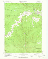 1969 Mt. Jewett1973 Print · USGSThe Allegheny highlands in the late sixties reveal an landscape of deep-woods industry and remote rail stops. Genealogists and historians can trace family roots through Mt Jewett, local sites like Lebanon Ch, and old settlements at Sergeant and Hutchins.4 unique versions available
End of results
Showing maps 1-1 of 1
Top cities near Cartwrights Crossing
- Saint Marys historical maps
- Kane historical maps
- Johnsonburg historical maps
- Lafayette Township historical maps
- Sheffield Township historical maps
- Wetmore historical maps
See more
Frequently asked questions
- What are the different types of historical maps available for Cartwrights Crossing?
- What is the oldest map of Cartwrights Crossing?
- Where can I purchase historical maps of Cartwrights Crossing for my home or office?
- Where can I download high-res historical maps of Cartwrights Crossing?
- Are there historical topographic maps available for Cartwrights Crossing?
- Is there historical aerial imagery available for Cartwrights Crossing?
- Where are historical maps of Cartwrights Crossing sourced from?