1990s Maps of Eldred Township, Pennsylvania
Explore 5 historic maps of Eldred Township from the 1990s. These maps offer a rare glimpse into what life looked like during the 1990s — showing old roads, neighborhoods, homes, and landmarks that have changed or disappeared over time.
Whether you're researching your family's past, planning a metal detecting trip, or studying how Eldred Township's landscape evolved across the 1990s, these high-resolution maps are a powerful tool for exploring the history of this region.
- Focus on a specific era: All maps on this page are from the 1990s, giving you a focused view of this time period.
- See what’s changed: Compare century-old streets, trails, and buildings to today's modern landscape using overlays and satellite layers.
- Research with precision: Use these maps for genealogy, historical research, land use analysis, or educational projects.
- View, download, or print: Maps are fully viewable online in high resolution, and can be downloaded or printed for your own records.
Start exploring Eldred Township's history through authentic maps from the 1990s. This is your window into the past.
Eldred Township, PA maps
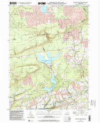
(5)- 1992 Map of Kunkletown, 1995 Print
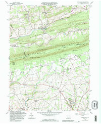 1992 Kunkletown1995 Print · USGSNorthampton and Monroe counties are shown in the 1990s as rural communities nestled against the Blue Mountain ridge. Trace ancestral roots through Salem Ch, find the old Township Sch, or locate former extraction sites like the Quarries and Claypits.
 - 1997 Map of Palmerton, 1999 Print
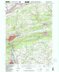 1997 Palmerton1999 Print · USGSThe industrial corridor of the Lehigh Valley meets the ridgeline of the Appalachians in the late nineties. Researchers can trace the legacy of the Lehigh Canal and identify local landmarks like the Drive-in Theater, Bethany Tabernacle, and Slatington Airport.
 - 1997 Map of Kunkletown, 1999 Print
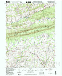 1997 Kunkletown1999 Print · USGSNorthampton County at the end of the century reflects a landscape of ridge-top trails and deep-seated industrial roots. Genealogists and historians can trace the foundations of Kunkletown, family-named sites like Arndts, and local landmarks like Fairview Cem.
 - 1999 Map of Brodheadsville, 2001 Print
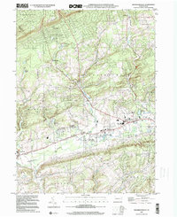 1999 Brodheadsville2001 Print · USGSThe Pocono foothills near the turn of the millennium show a landscape of growing mountain communities and protected wilds. Trace local family roots at Effort Cem, St Johns Ch, or the old Polk Sch while exploring the banks of Pohopoco Creek.
 - 1999 Map of Pohopoco Mountain, 2002 Print
 1999 Pohopoco Mountain2002 Print · USGSCarbon and Monroe Counties were a mix of protected forests and expanding residential enclaves at the end of the twentieth century. Researchers can trace land use through Hickory Run State Park or locate family plots at Dotters Corners Cem.
End of results
Showing maps 1-5 of 5
Top cities near Eldred Township
- Allentown historical maps
- Bethlehem historical maps
- Easton historical maps
- Fullerton historical maps
- Lower Saucon Township historical maps
- Hanover Township historical maps
See more
Top neighborhoods of Eldred Township
- Kunkletown historical maps
- Smith Gap historical maps
- Fiddletown historical maps
- Kingswood Estates historical maps
Frequently asked questions
- What are the different types of historical maps available for Eldred Township?
- What is the oldest map of Eldred Township?
- Where can I purchase historical maps of Eldred Township for my home or office?
- Where can I download high-res historical maps of Eldred Township?
- Are there historical topographic maps available for Eldred Township?
- Is there historical aerial imagery available for Eldred Township?
- Where are historical maps of Eldred Township sourced from?