Old Maps of Lansdale, Montgomery County for Academic Research
Study the evolution of Lansdale with 23 high-resolution historic maps. Whether you're teaching, researching, or modeling changes in land use, these maps provide essential visual documentation of urban, environmental, and geographic change.
- Analyze long-term change: Track patterns in development, transportation, and natural features.
- Ideal for environmental or urban studies: Support academic projects with primary historical map data.
- Use in the classroom or lab: Educators and researchers rely on these maps to bring historical context to life.
These maps are a powerful tool for teaching, research, and visualizing how Lansdale has changed over the decades.
Lansdale, Montgomery County maps
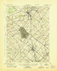
(23)- 1888 Map of Quakertown, 1963 Print
 1888 Quakertown1963 Print · USGSCovers Lansdale, including Limerick Township, Skippack Township, and other nearby areas
 - 1890 Map of Quakertown
 1890 Quakertown1890 Print · USGSCovers Lansdale, including Limerick Township, Skippack Township, and other nearby areas
 - 1894 Map of Quakertown
 1894 Quakertown1894 Print · USGSCovers Lansdale, including Limerick Township, Skippack Township, and other nearby areas9 unique versions available
 - 1894 Map of Norristown, 1959 Print
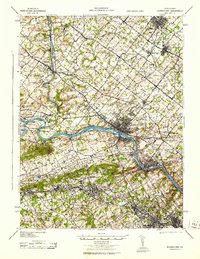
 1894 Norristown1959 Print · USGSCovers Lansdale, including Philadelphia, Norristown, and other nearby areas
 - 1895 Map of Norristown, 1898 Print
 1895 Norristown1898 Print · USGSCovers Lansdale, including Philadelphia, Norristown, and other nearby areas11 unique versions available
 - 1896 Map of Norristown
 1896 Norristown1896 Print · USGSCovers Lansdale, including Philadelphia, Norristown, and other nearby areas
 - 1942 Map of Norristown
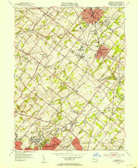
 1942 Norristown1942 Print · USGSCovers Lansdale, including Philadelphia, Abington Township, and other nearby areas
 - 1943 Map of Telford
 1943 Telford1943 Print · USGSCovers Lansdale, including Franconia Township, Hilltown Township, and other nearby areas
 - 1943 Map of Norristown
 1943 Norristown1943 Print · USGSCovers Lansdale, including Philadelphia, Norristown, and other nearby areas
 - 1944 Map of Newark, 1971 Print
 1944 Newark1971 Print · USGSCovers Lansdale, including New York, Philadelphia, and other nearby areas5 unique versions available
 - 1949 Map of Newark
 1949 Newark1949 Print · USGSCovers Lansdale, including New York, Philadelphia, and other nearby areas3 unique versions available
 - 1951 Map of Lansdale, 1953 Print
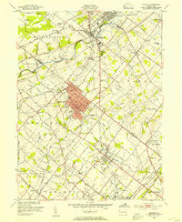
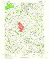
 1951 Lansdale1953 Print · USGSCovers Lansdale, including Whitemarsh Township, Skippack Township, and other nearby areas2 unique versions available
 - 1953 Map of Telford, 1954 Print
 1953 Telford1954 Print · USGSCovers Lansdale, including Franconia Township, Hilltown Township, and other nearby areas
 - 1956 Map of Newark
 1956 Newark1956 Print · USGSCovers Lansdale, including New York, Philadelphia, and other nearby areas2 unique versions available
 - 1957 Map of Newark
 1957 Newark1957 Print · USGSCovers Lansdale, including New York, Philadelphia, and other nearby areas
 - 1960 Map of Newark
 1960 Newark1960 Print · USGSCovers Lansdale, including New York, Philadelphia, and other nearby areas3 unique versions available
 - 1960 Map of Telford, 1963 Print
 1960 Telford1963 Print · USGSCovers Lansdale, including Franconia Township, Hilltown Township, and other nearby areas5 unique versions available
 - 1964 Map of Newark
 1964 Newark1964 Print · USGSCovers Lansdale, including New York, Philadelphia, and other nearby areas2 unique versions available
 - 1966 Map of Lansdale, 1968 Print
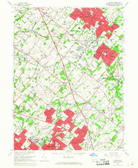 1966 Lansdale1968 Print · USGSCovers Lansdale, including Whitemarsh Township, Skippack Township, and other nearby areas5 unique versions available
 - 1984 Map of Reading, 1986 Print
 1984 Reading1986 Print · USGSCovers Lansdale, including Philadelphia, Reading, and other nearby areas2 unique versions available
 - 1995 Map of Telford, 1996 Print
 1995 Telford1996 Print · USGSCovers Lansdale, including Franconia Township, Hilltown Township, and other nearby areas
 - 1997 Map of Telford, 2000 Print
 1997 Telford2000 Print · USGSCovers Lansdale, including Franconia Township, Hilltown Township, and other nearby areas
 - 1999 Map of Lansdale, 2001 Print
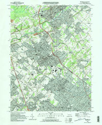
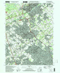
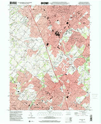 1999 Lansdale2001 Print · USGSCovers Lansdale, including Whitemarsh Township, Skippack Township, and other nearby areas
End of results
Showing maps 1-23 of 23
Frequently asked questions
- What are the different types of historical maps available for Lansdale?
- What is the oldest map of Lansdale?
- Where can I purchase historical maps of Lansdale for my home or office?
- Where can I download high-res historical maps of Lansdale?
- Are there historical topographic maps available for Lansdale?
- Is there historical aerial imagery available for Lansdale?
- Where are historical maps of Lansdale sourced from?