1990s Maps of Overbrook, Philadelphia
Explore 2 historic maps of Overbrook from the 1990s. These maps offer a rare glimpse into what life looked like during the 1990s — showing old roads, neighborhoods, homes, and landmarks that have changed or disappeared over time.
Whether you're researching your family's past, planning a metal detecting trip, or studying how Overbrook's landscape evolved across the 1990s, these high-resolution maps are a powerful tool for exploring the history of this region.
- Focus on a specific era: All maps on this page are from the 1990s, giving you a focused view of this time period.
- See what’s changed: Compare century-old streets, trails, and buildings to today's modern landscape using overlays and satellite layers.
- Research with precision: Use these maps for genealogy, historical research, land use analysis, or educational projects.
- View, download, or print: Maps are fully viewable online in high resolution, and can be downloaded or printed for your own records.
Start exploring Overbrook's history through authentic maps from the 1990s. This is your window into the past.
Overbrook, Philadelphia maps
(2)- 1995 Map of Philadelphia, 1999 Print
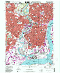 1995 Philadelphia1999 Print · USGSPhiladelphia at the close of the twentieth century remains a dense landscape of historic neighborhoods and industrial riverfronts. Genealogists and historians can trace parish boundaries and burial grounds like Old Cathedral Cemetery or locate landmarks such as Independence Hall and the U S Naval Shipyard.
 - 1997 Map of Germantown, 1998 Print
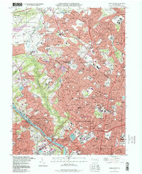 1997 Germantown1998 Print · USGSNorthwest Philadelphia and its Montgomery County suburbs are shown in the late twentieth century as a dense network of rail-linked neighborhoods. Researchers can trace family history through massive burial grounds like West Laurel Hill Cemetery or locate local landmarks such as Germantown Hospital.
End of results
Showing maps 1-2 of 2
Frequently asked questions
- What are the different types of historical maps available for Overbrook?
- What is the oldest map of Overbrook?
- Where can I purchase historical maps of Overbrook for my home or office?
- Where can I download high-res historical maps of Overbrook?
- Are there historical topographic maps available for Overbrook?
- Is there historical aerial imagery available for Overbrook?
- Where are historical maps of Overbrook sourced from?