1960s Maps of Pike County, Pennsylvania
Explore 17 historic maps of Pike County from the 1960s. These maps offer a rare glimpse into what life looked like during the 1960s — showing old roads, neighborhoods, homes, and landmarks that have changed or disappeared over time.
Whether you're researching your family's past, planning a metal detecting trip, or studying how Pike County's landscape evolved across the 1960s, these high-resolution maps are a powerful tool for exploring the history of this region.
- Focus on a specific era: All maps on this page are from the 1960s, giving you a focused view of this time period.
- See what’s changed: Compare century-old streets, trails, and buildings to today's modern landscape using overlays and satellite layers.
- Research with precision: Use these maps for genealogy, historical research, land use analysis, or educational projects.
- View, download, or print: Maps are fully viewable online in high resolution, and can be downloaded or printed for your own records.
Start exploring Pike County's history through authentic maps from the 1960s. This is your window into the past.
Pike County, PA maps
(17)- 1962 Map of Scranton, 1977 Print
 1962 Scranton1977 Print · USGSThe industrial heart of eastern Pennsylvania and the New York Catskills are captured here in the early sixties. Genealogists and historians can trace the dense valley settlements from Scranton to Wilkes-Barre and the rail lines of the Erie Lackawanna Railroad.2 unique versions available
 - 1965 Map of Scranton
 1965 Scranton1965 Print · USGSThe tri-state highlands of Pennsylvania, New York, and New Jersey come alive in the mid-sixties as industry and recreation converge. Trace the intricate rail lines of the Erie Lackawanna RR or locate landmarks like the U S Military Academy.2 unique versions available
 - 1965 Map of Shohola, 1967 Print
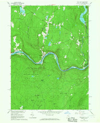
 1965 Shohola1967 Print · USGSThe Delaware River valley in the mid-sixties shows the rugged meeting of river and rail along the Erie Lackawanna. Trace local history at Minisink Battlefield Memorial or find family sites at German Hill Cem and Shohola Sch.5 unique versions available
 - 1965 Map of Edgemere, 1967 Print
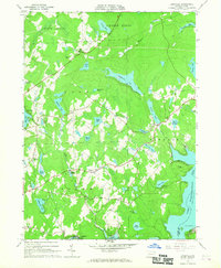
 1965 Edgemere1967 Print · USGSThe Poconos highlands in the 1960s reveal a landscape of summer camps and residential estates tucked between glacial lakes and dense woods. Trace the development of Sagamore Estates, find remote outposts like Camp Speers, and follow old trails through Dark Swamp.4 unique versions available
 - 1965 Map of Pond Eddy, 1967 Print
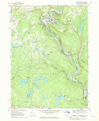
 1965 Pond Eddy1967 Print · USGSThe Delaware River gorge and the ERIE-LACKAWANNA rail line dominate this mid-sixties border landscape between New York and Pennsylvania. Genealogists and hikers can trace old routes near Pond Eddy, find the Sacred Heart Ch, or explore the deep woods of State Game Lands No 209.5 unique versions available
 - 1966 Map of Hawley, 1967 Print
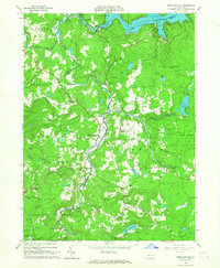
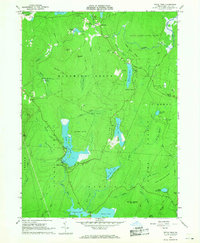
 1966 Hawley1967 Print · USGSIn the mid-1960s, the recreation-heavy landscape of the Wayne and Pike county border was defined by the massive Lake Wallenpaupack. Genealogists and historians can trace local ties through the Paupack Cem, small rural settlements like Tafton, and the Erie-Lackawanna rail corridor.3 unique versions available
 - 1966 Map of Lakeville, 1967 Print
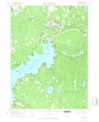
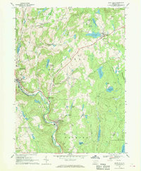
 1966 Lakeville1967 Print · USGSWayne and Pike Counties in the mid-1960s reveal a landscape of glacial lakes and growing recreational retreats. Researchers can trace the early developments of Lakeville, locate the Drive-in Theater near Pink, or find family sites like St Marys Church.3 unique versions available
 - 1966 Map of Rowland, 1967 Print
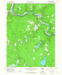
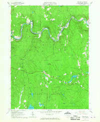 1966 Rowland1967 Print · USGSThe Lackawaxen River valley and the Erie-Lackawanna RR corridor are captured here during the mid-sixties. Researchers can trace historic Pike County settlements like Glen Eyre, find the Pillar of Fire community, and locate Mt Moriah Cem.4 unique versions available
 - 1966 Map of Newfoundland, 1967 Print
 1966 Newfoundland1967 Print · USGSPike and Wayne counties are captured here in the mid-1960s, showing a landscape defined by the Wallenpaupack waters and forested ridges. Trace family history through Newfoundland, Angels, and local landmarks like Pine Grove Cem.3 unique versions available
 - 1966 Map of Buck Hill Falls, 1968 Print
 1966 Buck Hill Falls1968 Print · USGSThe Pocono plateau comes alive in the mid-1960s, showing a region balanced between recreation and rail infrastructure. Locate landmarks like Buck Hill Falls and Pocono Playhouse or trace the ERIE-LACKAWANNA rail line through Cresco.4 unique versions available
 - 1966 Map of Promised Land, 1968 Print
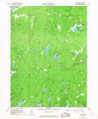
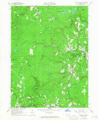
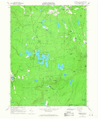 1966 Promised Land1968 Print · USGSPike County's high forest plateaus are captured here in the mid-sixties, a period of established conservation and recreation. Genealogists and hikers can trace the roads around Roemersville, find the Blooming Grove Sch, and locate the Lookout Tower on High Knob.3 unique versions available
 - 1966 Map of Pecks Pond, 1968 Print
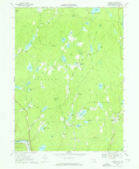
 1966 Pecks Pond1968 Print · USGSThe Pocono plateau in the mid-1960s is defined here by its dense network of glacial lakes and growing recreation communities. Researchers can trace local landmarks like Pecks Pond, the early development at Hemlock Farms, and family-named features like Madden Hill.3 unique versions available
 - 1967 Map of Eldred, 1969 Print
 1967 Eldred1969 Print · USGSSullivan County upland life is preserved here in the late sixties, from the village of Eldred to the Tenmile River valley. Trace local history at the Central Sch, Beaver Brook Cem, or the Meadowbrook Landing Strip among the many lakes.2 unique versions available
 - 1967 Map of White Mills, 1970 Print
 1967 White Mills1970 Print · USGSWayne County in the late 1960s shows a landscape of river-valley industry and upland summer camps. Researchers can trace the Erie Lackawanna rail line through White Mills or locate local landmarks like the Drive-in Theater and St Josephs Ch.4 unique versions available
 - 1968 Map of Narrowsburg, 1969 Print
 1968 Narrowsburg1969 Print · USGSThe upper Delaware River valley comes alive in the late sixties as the river winds past Narrowsburg and the Erie-Lackawanna railroad. Trace family roots at Glen Cove Cem or explore the shores of Teedyuskung Lake and Welcome Lake.3 unique versions available
 - 1969 Map of Port Jervis North, 1972 Print
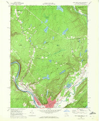 1969 Port Jervis North1972 Print · USGSThe Port Jervis area in the late sixties served as a vital river and rail crossroads where New York, Pennsylvania, and New Jersey meet. Researchers can trace family sites in Germantown, locate the Agudath Achim Cem, or follow the Erie Lackawanna Railroad through the valley.3 unique versions available
 - 1969 Map of Port Jervis South, 1972 Print
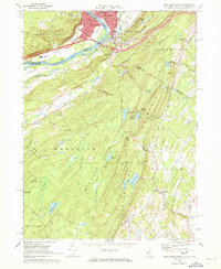 1969 Port Jervis South1972 Print · USGSThe tri-state border region comes alive in the late sixties, highlighting the urban density of Port Jervis against the crest of the Kittatinny Mountain. Genealogists can find St Marys Cem and Seeley Cem, while hikers can trace the Appalachian Trail through High Point State Park.3 unique versions available
End of results
Showing maps 1-17 of 17
Top cities of Pike County
- Lackawaxen Township historical maps
- Blooming Grove Township historical maps
- Matamoras historical maps
- Shohola Township historical maps
Frequently asked questions
- What are the different types of historical maps available for Pike County?
- What is the oldest map of Pike County?
- Where can I purchase historical maps of Pike County for my home or office?
- Where can I download high-res historical maps of Pike County?
- Are there historical topographic maps available for Pike County?
- Is there historical aerial imagery available for Pike County?
- Where are historical maps of Pike County sourced from?