1940s Maps of Saw Creek, Lehman Township
Explore 3 historic maps of Saw Creek from the 1940s. These maps offer a rare glimpse into what life looked like during the 1940s — showing old roads, neighborhoods, homes, and landmarks that have changed or disappeared over time.
Whether you're researching your family's past, planning a metal detecting trip, or studying how Saw Creek's landscape evolved across the 1940s, these high-resolution maps are a powerful tool for exploring the history of this region.
- Focus on a specific era: All maps on this page are from the 1940s, giving you a focused view of this time period.
- See what’s changed: Compare century-old streets, trails, and buildings to today's modern landscape using overlays and satellite layers.
- Research with precision: Use these maps for genealogy, historical research, land use analysis, or educational projects.
- View, download, or print: Maps are fully viewable online in high resolution, and can be downloaded or printed for your own records.
Start exploring Saw Creek's history through authentic maps from the 1940s. This is your window into the past.
Saw Creek, Lehman Township maps
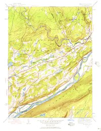
(3)- 1943 Map of Bushkill
 1943 Bushkill1943 Print · USGSMonroe County and the Delaware River valley are captured in the early 1940s during a time of rural persistence and local industry. Genealogists and historians can locate family landmarks like Dimicks Ferry, St Thomas Chapel, and the vanished sites of Craig Meadows.2 unique versions available
 - 1944 Map of Bushkill, 1956 Print
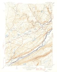
 1944 Bushkill1956 Print · USGSThe Delaware Water Gap region is seen here during the mid-1940s, just as the mountain landscape was becoming a premier recreation destination. Genealogists and hikers can trace old river crossings like Dimicks Ferry and landmark sites such as Bushkill Falls and Sand Hill Ch Cem.7 unique versions available
 - 1947 Map of Bushkill
 1947 Bushkill1947 Print · USGSThe Delaware River valley in the mid-1940s reveals a landscape of river-crossing points and upland ridges before the major changes of the later century. Trace local family roots at Dimicks Ferry, Middle Smithfield Sch, or the small settlement of Shoemakers.2 unique versions available
End of results
Showing maps 1-3 of 3
Top cities near Saw Creek
- East Stroudsburg historical maps
- Delaware historical maps
- Blairstown historical maps
- Stroudsburg historical maps
- Allamuchy Township historical maps
- Hampton Township historical maps
See more
Frequently asked questions
- What are the different types of historical maps available for Saw Creek?
- What is the oldest map of Saw Creek?
- Where can I purchase historical maps of Saw Creek for my home or office?
- Where can I download high-res historical maps of Saw Creek?
- Are there historical topographic maps available for Saw Creek?
- Is there historical aerial imagery available for Saw Creek?
- Where are historical maps of Saw Creek sourced from?