1990s Maps of Palmyra Township, Pennsylvania
Explore 8 historic maps of Palmyra Township from the 1990s. These maps offer a rare glimpse into what life looked like during the 1990s — showing old roads, neighborhoods, homes, and landmarks that have changed or disappeared over time.
Whether you're researching your family's past, planning a metal detecting trip, or studying how Palmyra Township's landscape evolved across the 1990s, these high-resolution maps are a powerful tool for exploring the history of this region.
- Focus on a specific era: All maps on this page are from the 1990s, giving you a focused view of this time period.
- See what’s changed: Compare century-old streets, trails, and buildings to today's modern landscape using overlays and satellite layers.
- Research with precision: Use these maps for genealogy, historical research, land use analysis, or educational projects.
- View, download, or print: Maps are fully viewable online in high resolution, and can be downloaded or printed for your own records.
Start exploring Palmyra Township's history through authentic maps from the 1990s. This is your window into the past.
Palmyra Township, PA maps
(8)- 1992 Map of Newfoundland, 1995 Print
 1992 Newfoundland1995 Print · USGSThe headwaters of the Wallenpaupack in Wayne and Pike Counties appear here as a landscape of small villages and forested slopes in the early nineties. Researchers can trace family sites at Newfoundland, Haags Mill, and Angels, or locate old landmarks like Pine Grove Cem.
 - 1994 Map of Hawley, 1995 Print
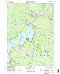 1994 Hawley1995 Print · USGSThe Lake Wallenpaupack region is shown here in the mid-nineties as the community grew around the water's edge and the Lackawaxen River. Genealogists and local historians can trace family sites at Paupack Cem, Pine Grove Cem, and the old settlement of Wilsonville.
 - 1994 Map of Promised Land, 1995 Print
 1994 Promised Land1995 Print · USGSPike County was a center for public conservation and wilderness recreation in the mid-1990s. Genealogists and hikers can trace the roads around Blooming Grove or locate landmarks like the Good Shepherd Ch and the Lookout Tower.
 - 1994 Map of Lakeville, 1996 Print
 1994 Lakeville1996 Print · USGSWayne County and Pike County meet along the western shore of Lake Wallenpaupack in the mid-1990s as the area's lake-centered communities continue to grow. Family historians can locate family-named landmarks and old rural sites like Tisdale Cem, St Marys Ch, and the settlement of Arlington.
 - 1997 Map of Promised Land, 1998 Print
 1997 Promised Land1998 Print · USGSThe Pocono Plateau comes into focus in the late nineties, showing a landscape of deep forests and glacial lakes. Genealogists and hikers can trace the foundations of Roemersville, the Blooming Grove Sch, and the shores of Bruce Lake.
 - 1997 Map of Hawley, 2000 Print
 1997 Hawley2000 Print · USGSLake Wallenpaupack and the surrounding Poconos plateau are shown here as they appeared in the 1990s. Researchers can locate local landmarks like the Paupack Cem, Mt Bay Airstrip, and the Wallenpaupack Area High Sch.
 - 1999 Map of Rowland, 2001 Print
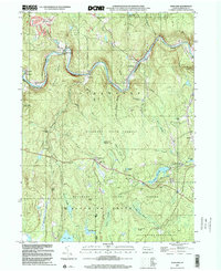 1999 Rowland2001 Print · USGSThe Lackawaxen River valley and the surrounding Pennsylvania state forests are captured here at the end of the century. Genealogists can trace family names and sites from Germantown to Rowland, including Mt Moriah Cem and the Pillar of Fire Ch.
 - 1999 Map of Newfoundland, 2001 Print
 1999 Newfoundland2001 Print · USGSThe Wallenpaupack Creek valley at the turn of the millennium shows a landscape of deep forests and quiet crossroads. Researchers can trace family sites at Zion Cem or explore established settlements like Newfoundland and South Sterling.
End of results
Showing maps 1-8 of 8
Top cities near Palmyra Township
- Tobyhanna historical maps
- Lackawaxen Township historical maps
- Honesdale historical maps
- Blooming Grove Township historical maps
- Damascus Township historical maps
- Waymart historical maps
See more
Top neighborhoods of Palmyra Township
- Paupack historical maps
- Tafton historical maps
- Tanglewood historical maps
- Tanglewood Estate historical maps
- Wilsonville historical maps
Frequently asked questions
- What are the different types of historical maps available for Palmyra Township?
- What is the oldest map of Palmyra Township?
- Where can I purchase historical maps of Palmyra Township for my home or office?
- Where can I download high-res historical maps of Palmyra Township?
- Are there historical topographic maps available for Palmyra Township?
- Is there historical aerial imagery available for Palmyra Township?
- Where are historical maps of Palmyra Township sourced from?