1990s Maps of Parkers Glen, Shohola Township
Explore 2 historic maps of Parkers Glen from the 1990s. These maps offer a rare glimpse into what life looked like during the 1990s — showing old roads, neighborhoods, homes, and landmarks that have changed or disappeared over time.
Whether you're researching your family's past, planning a metal detecting trip, or studying how Parkers Glen's landscape evolved across the 1990s, these high-resolution maps are a powerful tool for exploring the history of this region.
- Focus on a specific era: All maps on this page are from the 1990s, giving you a focused view of this time period.
- See what’s changed: Compare century-old streets, trails, and buildings to today's modern landscape using overlays and satellite layers.
- Research with precision: Use these maps for genealogy, historical research, land use analysis, or educational projects.
- View, download, or print: Maps are fully viewable online in high resolution, and can be downloaded or printed for your own records.
Start exploring Parkers Glen's history through authentic maps from the 1990s. This is your window into the past.
Parkers Glen, Shohola Township maps
(2)- 1994 Map of Shohola, 1995 Print
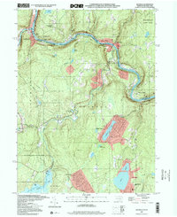
 1994 Shohola1995 Print · USGSPike County and the Delaware River valley are captured here in the mid-1990s, showing a landscape shaped by river recreation and highland game lands. Researchers can trace local heritage at St Anns Ch, locate the historic Roebling Bridge, or explore family sites near German Hill Cem.
 - 1997 Map of Shohola, 2000 Print
 1997 Shohola2000 Print · USGSThe Delaware River valley in the late nineties preserved a balance between historic settlements and emerging recreation areas. Researchers can trace the legacy of the region through the Roebling Bridge, German Hill Cem, and the Minisink Battlefield County Park Monument.
End of results
Showing maps 1-2 of 2
Top cities near Parkers Glen
- Thompson historical maps
- Fallsburg historical maps
- Wantage historical maps
- Port Jervis historical maps
- Deerpark historical maps
- Monticello historical maps
See more
Frequently asked questions
- What are the different types of historical maps available for Parkers Glen?
- What is the oldest map of Parkers Glen?
- Where can I purchase historical maps of Parkers Glen for my home or office?
- Where can I download high-res historical maps of Parkers Glen?
- Are there historical topographic maps available for Parkers Glen?
- Is there historical aerial imagery available for Parkers Glen?
- Where are historical maps of Parkers Glen sourced from?