1990s Maps of Deer Lake, West Brunswick Township
Explore 2 historic maps of Deer Lake from the 1990s. These maps offer a rare glimpse into what life looked like during the 1990s — showing old roads, neighborhoods, homes, and landmarks that have changed or disappeared over time.
Whether you're researching your family's past, planning a metal detecting trip, or studying how Deer Lake's landscape evolved across the 1990s, these high-resolution maps are a powerful tool for exploring the history of this region.
- Focus on a specific era: All maps on this page are from the 1990s, giving you a focused view of this time period.
- See what’s changed: Compare century-old streets, trails, and buildings to today's modern landscape using overlays and satellite layers.
- Research with precision: Use these maps for genealogy, historical research, land use analysis, or educational projects.
- View, download, or print: Maps are fully viewable online in high resolution, and can be downloaded or printed for your own records.
Start exploring Deer Lake's history through authentic maps from the 1990s. This is your window into the past.
Deer Lake, West Brunswick Township maps
(2)- 1999 Map of Orwigsburg, 2001 Print
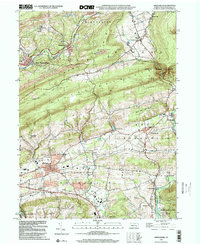 1999 Orwigsburg2001 Print · USGSSchuylkill County at the end of the millennium reveals a landscape of industrial coal roots and growing communities near the Schuylkill River. Genealogists and local historians can trace locations like Pinedale Sch, Bethel Ch, and the Drive-in Theater.
 - 1999 Map of Auburn, 2001 Print
 1999 Auburn2001 Print · USGSSchuylkill and Berks counties met at the turn of the millennium along the steep ridges of Blue Mountain and the winding river valleys. Researchers can trace rural schoolhouse locations like Tunnel Sch and historic local congregations at Salem Ch or St Michaels Ch.
End of results
Showing maps 1-2 of 2
Frequently asked questions
- What are the different types of historical maps available for Deer Lake?
- What is the oldest map of Deer Lake?
- Where can I purchase historical maps of Deer Lake for my home or office?
- Where can I download high-res historical maps of Deer Lake?
- Are there historical topographic maps available for Deer Lake?
- Is there historical aerial imagery available for Deer Lake?
- Where are historical maps of Deer Lake sourced from?