1990s Maps of Honesdale, Pennsylvania
Explore 2 historic maps of Honesdale from the 1990s. These maps offer a rare glimpse into what life looked like during the 1990s — showing old roads, neighborhoods, homes, and landmarks that have changed or disappeared over time.
Whether you're researching your family's past, planning a metal detecting trip, or studying how Honesdale's landscape evolved across the 1990s, these high-resolution maps are a powerful tool for exploring the history of this region.
- Focus on a specific era: All maps on this page are from the 1990s, giving you a focused view of this time period.
- See what’s changed: Compare century-old streets, trails, and buildings to today's modern landscape using overlays and satellite layers.
- Research with precision: Use these maps for genealogy, historical research, land use analysis, or educational projects.
- View, download, or print: Maps are fully viewable online in high resolution, and can be downloaded or printed for your own records.
Start exploring Honesdale's history through authentic maps from the 1990s. This is your window into the past.
Honesdale, PA maps
(2)- 1999 Map of White Mills, 2001 Print
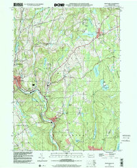 1999 White Mills2001 Print · USGSWayne County’s river valleys and lake districts are captured here at the close of the twentieth century. Genealogists and local historians can trace small-town life through landmarks like White Mills, the Vine Hill Cem, and St Josephs Ch.
 - 1999 Map of Honesdale, 2002 Print
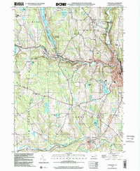 1999 Honesdale2002 Print · USGSHonesdale and the northern Pennsylvania lake country are captured here at the close of the century. Genealogists and local historians can trace family locations through the Schoonover Cem, the Hoadley Sch, and the Old Railroad Grade.
End of results
Showing maps 1-2 of 2
Top cities near Honesdale
- Lackawaxen Township historical maps
- Blooming Grove Township historical maps
- Damascus Township historical maps
- Clifford Township historical maps
- Delaware historical maps
- Waymart historical maps
See more
Top neighborhoods of Honesdale
Frequently asked questions
- What are the different types of historical maps available for Honesdale?
- What is the oldest map of Honesdale?
- Where can I purchase historical maps of Honesdale for my home or office?
- Where can I download high-res historical maps of Honesdale?
- Are there historical topographic maps available for Honesdale?
- Is there historical aerial imagery available for Honesdale?
- Where are historical maps of Honesdale sourced from?