1900-1909 Maps of Sewickley Township, Pennsylvania
Explore 7 historic maps of Sewickley Township from 1900-1909. These maps offer a rare glimpse into what life looked like during the 1900s — showing old roads, neighborhoods, homes, and landmarks that have changed or disappeared over time.
Whether you're researching your family's past, planning a metal detecting trip, or studying how Sewickley Township's landscape evolved across the 1900s, these high-resolution maps are a powerful tool for exploring the history of this region.
- Focus on a specific era: All maps on this page are from the 1900s, giving you a focused view of this time period.
- See what’s changed: Compare century-old streets, trails, and buildings to today's modern landscape using overlays and satellite layers.
- Research with precision: Use these maps for genealogy, historical research, land use analysis, or educational projects.
- View, download, or print: Maps are fully viewable online in high resolution, and can be downloaded or printed for your own records.
Start exploring Sewickley Township's history through authentic maps from the 1900s. This is your window into the past.
Sewickley Township, PA maps
(7)- 1902 Map of Brownsville
 1902 Brownsville1902 Print · USGSThe Monongahela Valley was a powerhouse of Pennsylvania industry at the start of the twentieth century, defined by its coal mines and river-front rail lines. Researchers can trace the heritage of the National Pike and locate vanished works at Vesta Mine or Coal Bluff.
 - 1902 Map of Connellsville
 1902 Connellsville1902 Print · USGSThe Pennsylvania coke region comes alive at the turn of the century as a labyrinth of coal mines and competing rail lines. Researchers can trace the industrial footprint of Star Mines, explore the river landings along the Youghiogheny River, and find old junctions like Bells Mills.5 unique versions available
 - 1904 Map of Mc Keesport
 1904 Mc Keesport1904 Print · USGSAllegheny County at the height of its industrial era reveals a landscape of massive rail yards and riverfront steel towns. Genealogists can trace family roots through dense neighborhoods in Homestead, Wilkinsburg, and Braddock or locate ancestral plots in Homewood Cem.2 unique versions available
 - 1904 Map of Greensburg, 1963 Print
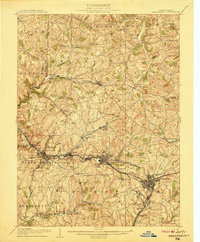
 1904 Greensburg1963 Print · USGSWestmoreland County at the dawn of the twentieth century was a landscape of industrial power and small-town growth. Genealogists can trace family footprints through Greensburg, find the Bulltown Schoolhouse, or follow the Pennsylvania Railroad through Jeannette and Manor.
 - 1906 Map of Brownsville
 1906 Brownsville1906 Print · USGSSouthwestern Pennsylvania’s river valleys were centers of industrial expansion when this survey was conducted. Genealogists can locate family homes and landmarks in riverfront towns like Monessen and Charleroi, or trace rural roots near Salem Church and Ginger Hill.4 unique versions available
 - 1906 Map of Greensburg
 1906 Greensburg1906 Print · USGSWestmoreland County at the height of its industrial growth is detailed here, showing a landscape defined by coal, glass, and rail. Researchers can trace ancestral roots at the Bulltown Schoolhouse or follow the early trolley and rail lines through Jeannette and Export.6 unique versions available
 - 1907 Map of Pittsburg
 1907 Pittsburg1907 Print · USGSSteel-industry heartlands and river-valley rail corridors define the Pittsburgh region in the early nineteen-hundreds. Trace the complex rail networks of the Union RR and Pennsylvania RR through industrial hubs like Homestead and Wilmerding.10 unique versions available
End of results
Showing maps 1-7 of 7
Top cities near Sewickley Township
- Pittsburgh historical maps
- Penn Hills historical maps
- Monroeville historical maps
- McKeesport historical maps
- West Mifflin historical maps
- Wilkinsburg historical maps
See more
Top neighborhoods of Sewickley Township
- Keystone historical maps
- Rillton historical maps
- Dick historical maps
- Fulton historical maps
- Lower Whyel historical maps
- Upper Whyel historical maps
See more
Frequently asked questions
- What are the different types of historical maps available for Sewickley Township?
- What is the oldest map of Sewickley Township?
- Where can I purchase historical maps of Sewickley Township for my home or office?
- Where can I download high-res historical maps of Sewickley Township?
- Are there historical topographic maps available for Sewickley Township?
- Is there historical aerial imagery available for Sewickley Township?
- Where are historical maps of Sewickley Township sourced from?