1990s Maps of Wyoming County, Pennsylvania
Explore 9 historic maps of Wyoming County from the 1990s. These maps offer a rare glimpse into what life looked like during the 1990s — showing old roads, neighborhoods, homes, and landmarks that have changed or disappeared over time.
Whether you're researching your family's past, planning a metal detecting trip, or studying how Wyoming County's landscape evolved across the 1990s, these high-resolution maps are a powerful tool for exploring the history of this region.
- Focus on a specific era: All maps on this page are from the 1990s, giving you a focused view of this time period.
- See what’s changed: Compare century-old streets, trails, and buildings to today's modern landscape using overlays and satellite layers.
- Research with precision: Use these maps for genealogy, historical research, land use analysis, or educational projects.
- View, download, or print: Maps are fully viewable online in high resolution, and can be downloaded or printed for your own records.
Start exploring Wyoming County's history through authentic maps from the 1990s. This is your window into the past.
Wyoming County, PA maps
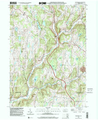
(9)- 1994 Map of Dalton, 1995 Print
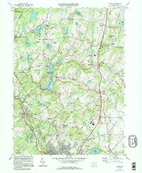 1994 Dalton1995 Print · USGSLackawanna County's rolling highlands and lake country appear here in the mid-1990s, showcasing a landscape of small crossroads and quiet cemeteries. Genealogists can trace family names through Decker Cem and Weatherby Cem or find old landmarks like St Gabriels Monastery.
 - 1994 Map of Ransom, 1995 Print
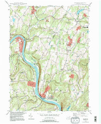 1994 Ransom1995 Print · USGSThe rural river valley near Scranton shows its late-twentieth-century character as the Susquehanna River flows past small hubs like Ransom and West Falls. Genealogists and local historians can trace landmarks like Newton Center Cem, the Exeter Twp Sch, and the winding Sullivan Trail.
 - 1994 Map of Hop Bottom, 1995 Print
 1994 Hop Bottom1995 Print · USGSSusquehanna County in the mid-1990s reveals a landscape of high ridges and glacial ponds centered on the borough of Hop Bottom. Genealogists and researchers can locate family landmarks like Squiers Cem, Union Ch, and the old settlement at Deckertown.
 - 1994 Map of Factoryville, 1996 Print
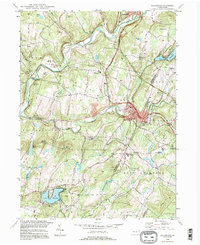 1994 Factoryville1996 Print · USGSThe rural landscapes and college towns of Wyoming and Lackawanna counties are detailed here in the mid-1990s. Genealogists can locate family sites at Pedrick Cem and Fairview Cem, or trace the development of Factoryville and Lake Winola.
 - 1997 Map of Dutch Mtn, 1999 Print
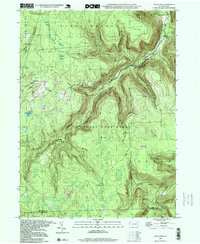 1997 Dutch Mtn1999 Print · USGSThe high-plateau wilderness of the Endless Mountains is captured here in the late nineties. Genealogists and hikers can trace the geography around Bellasylva, locate the Ricketts Fire Tower, and explore the wetlands of Crane Swamp.
 - 1998 Map of Laceyville, 1999 Print
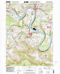
 1998 Laceyville1999 Print · USGSIn the Susquehanna River valley during the late nineties, this area shows the persistent geography of river-bend settlements and mountain gaps. Genealogists can locate family sites at Spring Hill Cem or trace the rural landscape near Spring Hill Sch and Skinners Eddy.
 - 1999 Map of Meshoppen, 2001 Print
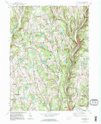
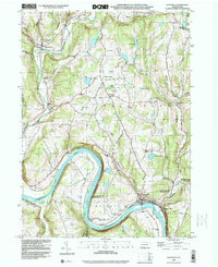
 1999 Meshoppen2001 Print · USGSThe Susquehanna River winds through Wyoming County at the turn of the millennium, shaping a landscape of deep valleys and narrow ridge-top settlements. Researchers can locate vanished rural landmarks like Russell Hill Sch, the Vosburg Tunnel, and the remote Mehoopany Fire Tower.
 - 1999 Map of Auburn Center, 2001 Print
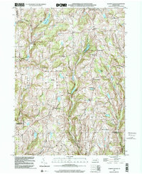 1999 Auburn Center2001 Print · USGSSusquehanna County remains a landscape of high ridges and rural crossroads at the close of the twentieth century. Genealogists can trace family landmarks and burial sites like Boles Cem, Jersey Hill Ch, and the settlement at Auburn Center.
 - 1999 Map of Lenoxville, 2001 Print
 1999 Lenoxville2001 Print · USGSSusquehanna County at the close of the twentieth century remains a landscape of high ridges and deep creek valleys. Genealogists and local historians can trace legacy sites like Maplewood Cem, Wright Sch, and the riverside settlement of Lenoxville.2 unique versions available
End of results
Showing maps 1-9 of 9
Top cities of Wyoming County
- Falls Township historical maps
- Tunkhannock historical maps
- Lemon Township historical maps
- Factoryville historical maps
- Mehoopany Township historical maps
- Noxen Township historical maps
See more
Frequently asked questions
- What are the different types of historical maps available for Wyoming County?
- What is the oldest map of Wyoming County?
- Where can I purchase historical maps of Wyoming County for my home or office?
- Where can I download high-res historical maps of Wyoming County?
- Are there historical topographic maps available for Wyoming County?
- Is there historical aerial imagery available for Wyoming County?
- Where are historical maps of Wyoming County sourced from?