1920s Maps of Nenahnezad, Shiprock Agency
Explore 2 historic maps of Nenahnezad from the 1920s. These maps offer a rare glimpse into what life looked like during the 1920s — showing old roads, neighborhoods, homes, and landmarks that have changed or disappeared over time.
Whether you're researching your family's past, planning a metal detecting trip, or studying how Nenahnezad's landscape evolved across the 1920s, these high-resolution maps are a powerful tool for exploring the history of this region.
- Focus on a specific era: All maps on this page are from the 1920s, giving you a focused view of this time period.
- See what’s changed: Compare century-old streets, trails, and buildings to today's modern landscape using overlays and satellite layers.
- Research with precision: Use these maps for genealogy, historical research, land use analysis, or educational projects.
- View, download, or print: Maps are fully viewable online in high resolution, and can be downloaded or printed for your own records.
Start exploring Nenahnezad's history through authentic maps from the 1920s. This is your window into the past.
Nenahnezad, Shiprock Agency maps
(2)- 1927 Map of Sulphur Spring
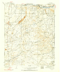
 1927 Sulphur Spring1927 Print · USGSSan Juan County was a region of remote outposts and river crossings during the late 1920s. Researchers can trace the early desert road network including the Shiprock Gallup Highway and locate historic hubs like Wheeler Trading Post and Bisti Trading Post.
 - 1928 Map of Kirtland, 1955 Print
 1928 Kirtland1955 Print · USGSSan Juan County at the close of the 1920s shows a landscape of riverfront farming and remote desert commerce. Genealogists and historians can trace the network of isolated hubs like Wheeler Trading Post, Nava PO, and the early workings of a Coal Mine.
End of results
Showing maps 1-2 of 2
Top cities near Nenahnezad
Frequently asked questions
- What are the different types of historical maps available for Nenahnezad?
- What is the oldest map of Nenahnezad?
- Where can I purchase historical maps of Nenahnezad for my home or office?
- Where can I download high-res historical maps of Nenahnezad?
- Are there historical topographic maps available for Nenahnezad?
- Is there historical aerial imagery available for Nenahnezad?
- Where are historical maps of Nenahnezad sourced from?