1940s Maps of Barnwell, South Carolina
Explore 2 historic maps of Barnwell from the 1940s. These maps offer a rare glimpse into what life looked like during the 1940s — showing old roads, neighborhoods, homes, and landmarks that have changed or disappeared over time.
Whether you're researching your family's past, planning a metal detecting trip, or studying how Barnwell's landscape evolved across the 1940s, these high-resolution maps are a powerful tool for exploring the history of this region.
- Focus on a specific era: All maps on this page are from the 1940s, giving you a focused view of this time period.
- See what’s changed: Compare century-old streets, trails, and buildings to today's modern landscape using overlays and satellite layers.
- Research with precision: Use these maps for genealogy, historical research, land use analysis, or educational projects.
- View, download, or print: Maps are fully viewable online in high resolution, and can be downloaded or printed for your own records.
Start exploring Barnwell's history through authentic maps from the 1940s. This is your window into the past.
Barnwell, SC maps
(2)- 1943 Map of Allendale
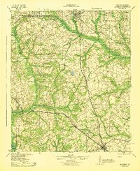 1943 Allendale1943 Print · USGSCoastal plain settlements and timberlands thrive along the Salkehatchie River in the early 1940s as rail lines connect rural communities. Genealogists can trace family-named landmarks and institutions like Chaney Grove Mill, Hercules School, and Siloam Ch.
 - 1943 Map of Williston
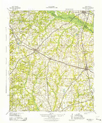 1943 Williston1943 Print · USGSBarnwell County in the early 1940s was a landscape of rail-linked towns and scattered rural communities. Genealogists can trace family roots through numerous local landmarks, including the Blessed Home Sch, Woodward Mill, and the community of Healing Springs.2 unique versions available
End of results
Showing maps 1-2 of 2
Top cities near Barnwell
- Allendale historical maps
- Williston historical maps
- Denmark historical maps
- Blackville historical maps
- Hilda historical maps
- Snelling historical maps
See more
Top neighborhoods of Barnwell
Frequently asked questions
- What are the different types of historical maps available for Barnwell?
- What is the oldest map of Barnwell?
- Where can I purchase historical maps of Barnwell for my home or office?
- Where can I download high-res historical maps of Barnwell?
- Are there historical topographic maps available for Barnwell?
- Is there historical aerial imagery available for Barnwell?
- Where are historical maps of Barnwell sourced from?