1980s Maps of Dale, South Carolina
Explore 2 historic maps of Dale from the 1980s. These maps offer a rare glimpse into what life looked like during the 1980s — showing old roads, neighborhoods, homes, and landmarks that have changed or disappeared over time.
Whether you're researching your family's past, planning a metal detecting trip, or studying how Dale's landscape evolved across the 1980s, these high-resolution maps are a powerful tool for exploring the history of this region.
- Focus on a specific era: All maps on this page are from the 1980s, giving you a focused view of this time period.
- See what’s changed: Compare century-old streets, trails, and buildings to today's modern landscape using overlays and satellite layers.
- Research with precision: Use these maps for genealogy, historical research, land use analysis, or educational projects.
- View, download, or print: Maps are fully viewable online in high resolution, and can be downloaded or printed for your own records.
Start exploring Dale's history through authentic maps from the 1980s. This is your window into the past.
Dale, SC maps
(2)- 1986 Map of Walterboro
 1986 Walterboro1986 Print · USGSThe South Carolina Lowcountry in the mid-eighties remains a world of expansive wetlands and historic river crossings. Genealogists and historians can trace the rural communities and landmarks of Colleton and Charleston counties, from the Baptist Church at Adams Run to the coastal reaches of Edisto Beach State Park.
 - 1988 Map of Dale
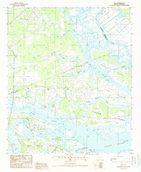 1988 Dale1988 Print · USGSCoastal Beaufort County in the late eighties is defined by the labyrinthine waterways and islands between the Combahee and Coosaw rivers. Genealogists and local historians can trace the Old RR Grade and find early sites at Dale, Lobeco, and Keans Neck.
End of results
Showing maps 1-2 of 2
Top cities near Dale
- Beaufort historical maps
- Port Royal historical maps
- Yemassee historical maps
- Blountville historical maps
Frequently asked questions
- What are the different types of historical maps available for Dale?
- What is the oldest map of Dale?
- Where can I purchase historical maps of Dale for my home or office?
- Where can I download high-res historical maps of Dale?
- Are there historical topographic maps available for Dale?
- Is there historical aerial imagery available for Dale?
- Where are historical maps of Dale sourced from?