1900s (20th Century) Maps of Townhouse Tennis Club, Hilton Head Island
Explore 12 historic maps of Townhouse Tennis Club from the 1900s (20th Century). These maps offer a rare glimpse into what life looked like during the 1900s — showing old roads, neighborhoods, homes, and landmarks that have changed or disappeared over time.
Whether you're researching your family's past, planning a metal detecting trip, or studying how Townhouse Tennis Club's landscape evolved across the 1900s, these high-resolution maps are a powerful tool for exploring the history of this region.
- Focus on a specific era: All maps on this page are from the 1900s, giving you a focused view of this time period.
- See what’s changed: Compare century-old streets, trails, and buildings to today's modern landscape using overlays and satellite layers.
- Research with precision: Use these maps for genealogy, historical research, land use analysis, or educational projects.
- View, download, or print: Maps are fully viewable online in high resolution, and can be downloaded or printed for your own records.
Start exploring Townhouse Tennis Club's history through authentic maps from the 1900s. This is your window into the past.
Townhouse Tennis Club, Hilton Head Island maps
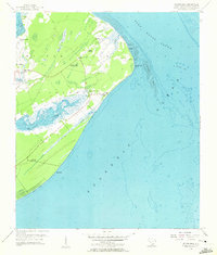
(12)- 1920 Map of Hilton Head
 1920 Hilton Head1920 Print · USGSCoastal Beaufort County appears here as it was just after the Great War, before the bridges and modern development arrived. Genealogists and maritime historians can trace the early settlement of Hilton Head and locate landmarks like the L.H. and Broad Creek.
 - 1920 Map of Bluffton
 1920 Bluffton1920 Print · USGSThe Georgia and South Carolina coastlines meet here in the early twentieth century, showing a world defined by tidal rivers and island outposts. Researchers can trace historic maritime landmarks like Ft. Pulaski, the Long Island Ferry, and family settlements at Spanish Wells or Hickory Bluff.
 - 1945 Map of Bluffton
 1945 Bluffton1945 Print · USGSThe Carolina Lowcountry and Georgia's sea islands appear here in the mid-forties, before modern bridges transformed the coast. Trace the early footprints of Bluffton and Spanish Wells, or locate maritime landmarks like Buckingham Ferry and the Oyster Packing Plant.
 - 1945 Map of Hilton Head
 1945 Hilton Head1945 Print · USGSCoastal South Carolina remains largely rural in the mid-1940s, showing the island long before its modern resort era. Genealogists can trace early community hubs like First Africian Ch, Oak Grove Ch, and the small settlement of Hilton Head.
 - 1947 Map of Savannah
 1947 Savannah1947 Print · USGSCoastal Georgia and South Carolina are captured here in the mid-forties, showing the rail-and-river networks of the Lowcountry. Genealogists and researchers can trace old crossroads and river towns from Statesboro to Beaufort, alongside military sites like Camp Stewart and Parris Island.
 - 1948 Map of Savannah
 1948 Savannah1948 Print · USGSThe Georgia and South Carolina Lowcountry comes alive in this post-war survey of the coast and its river-fed hinterlands. Genealogists and historians can trace rail lines like the Central of Georgia RR and find established settlements such as Isle of Hope and Sylvania.
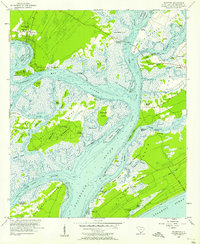
 - 1956 Map of Hilton Head, 1957 Print
 1956 Hilton Head1957 Print · USGSHilton Head Island is captured in the mid-1950s, showing a quiet maritime landscape before its transition into a major resort destination. Genealogists and historians can locate family landmarks like Drayton Cem or explore sites of local heritage including First African Ch and Fort Walker Ruin.4 unique versions available
 - 1956 Map of Bluffton, 1957 Print
 1956 Bluffton1957 Print · USGSThe South Carolina Lowcountry of the mid-fifties is a network of tidal reaches and quiet sea islands before the arrival of modern resorts. Trace ancestral sites and early infrastructure through the State Ferry Dock, Mikey Riley Sch, and the Baynard Ruins.5 unique versions available
 - 1957 Map of Savannah, 1967 Print
 1957 Savannah1967 Print · USGSThe Lowcountry and Georgia coastal plain are shown here in the late fifties, prior to modern expansion. Researchers can trace the rail-and-river economy through the Central of Georgia lines and the Ogeechee River wetlands.4 unique versions available
 - 1960 Map of Savannah
 1960 Savannah1960 Print · USGSCoastal Georgia and the South Carolina Lowcountry are captured in the late fifties, showcasing the intricate web of islands and tidal rivers before modern expansion. Researchers can trace the rail lines of the Atlantic Coast Line or locate sites like Parris Island, Beaufort, and the Tybee Lighthouse.
 - 1961 Map of Savannah
 1961 Savannah1961 Print · USGSThe Georgia and South Carolina Lowcountry comes alive in this mid-century survey of coastal marshes, barrier islands, and river networks. Genealogists and historians can trace the paths of the Seaboard Air Line RR, locate family sites near Isle of Hope, or study the grounds of Fort Stewart Military Reservation.2 unique versions available
 - 1978 Map of Beaufort
 1978 Beaufort1978 Print · USGSCoastal South Carolina and Georgia come to life in this detailed bathymetric study from the late seventies, featuring the intricate Sea Islands and the Savannah River mouth. Researchers can trace military history at Parris Island or locate inland settlements like Switzerland and Old Sheldon.2 unique versions available
End of results
Showing maps 1-12 of 12
Frequently asked questions
- What are the different types of historical maps available for Townhouse Tennis Club?
- What is the oldest map of Townhouse Tennis Club?
- Where can I purchase historical maps of Townhouse Tennis Club for my home or office?
- Where can I download high-res historical maps of Townhouse Tennis Club?
- Are there historical topographic maps available for Townhouse Tennis Club?
- Is there historical aerial imagery available for Townhouse Tennis Club?
- Where are historical maps of Townhouse Tennis Club sourced from?