1990s Maps of Fairway Ridge, Horry County
Explore 2 historic maps of Fairway Ridge from the 1990s. These maps offer a rare glimpse into what life looked like during the 1990s — showing old roads, neighborhoods, homes, and landmarks that have changed or disappeared over time.
Whether you're researching your family's past, planning a metal detecting trip, or studying how Fairway Ridge's landscape evolved across the 1990s, these high-resolution maps are a powerful tool for exploring the history of this region.
- Focus on a specific era: All maps on this page are from the 1990s, giving you a focused view of this time period.
- See what’s changed: Compare century-old streets, trails, and buildings to today's modern landscape using overlays and satellite layers.
- Research with precision: Use these maps for genealogy, historical research, land use analysis, or educational projects.
- View, download, or print: Maps are fully viewable online in high resolution, and can be downloaded or printed for your own records.
Start exploring Fairway Ridge's history through authentic maps from the 1990s. This is your window into the past.
Fairway Ridge, Horry County maps
(2)- 1990 Map of Myrtle Beach
 1990 Myrtle Beach1990 Print · USGSThe Grand Strand and the North Carolina borderlands are captured here in the decade before the base closure. Genealogists and historians can trace the development of Myrtle Beach and North Myrtle Beach alongside rural landmarks like Star Bluff Crossroads and Fort Caswell.
 - 1994 Map of Myrtle Beach, 1999 Print
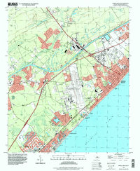 1994 Myrtle Beach1999 Print · USGSCoastal Horry County appears in the mid-1990s as the tourism economy and residential sprawl reshaped the Grand Strand. Genealogists and local historians can trace the footprint of the Myrtle Beach International Airport or locate family sites at Mt Carmel Ch and Socastee.
End of results
Showing maps 1-2 of 2
Frequently asked questions
- What are the different types of historical maps available for Fairway Ridge?
- What is the oldest map of Fairway Ridge?
- Where can I purchase historical maps of Fairway Ridge for my home or office?
- Where can I download high-res historical maps of Fairway Ridge?
- Are there historical topographic maps available for Fairway Ridge?
- Is there historical aerial imagery available for Fairway Ridge?
- Where are historical maps of Fairway Ridge sourced from?