1980s Maps of Covenant Towers, Myrtle Beach
Explore 2 historic maps of Covenant Towers from the 1980s. These maps offer a rare glimpse into what life looked like during the 1980s — showing old roads, neighborhoods, homes, and landmarks that have changed or disappeared over time.
Whether you're researching your family's past, planning a metal detecting trip, or studying how Covenant Towers's landscape evolved across the 1980s, these high-resolution maps are a powerful tool for exploring the history of this region.
- Focus on a specific era: All maps on this page are from the 1980s, giving you a focused view of this time period.
- See what’s changed: Compare century-old streets, trails, and buildings to today's modern landscape using overlays and satellite layers.
- Research with precision: Use these maps for genealogy, historical research, land use analysis, or educational projects.
- View, download, or print: Maps are fully viewable online in high resolution, and can be downloaded or printed for your own records.
Start exploring Covenant Towers's history through authentic maps from the 1980s. This is your window into the past.
Covenant Towers, Myrtle Beach maps
(2)- 1984 Map of Ocean Forest
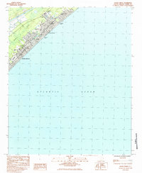 1984 Ocean Forest1984 Print · USGSCoastal South Carolina shows its expanding residential and resort footprint in the 1980s as Myrtle Beach moves north. Genealogists and historians can trace neighborhood development near Ocean Forest, find local institutions like Coastal Academy, or locate landmarks such as Memorial Stadium.2 unique versions available
 - 1986 Map of Myrtle Beach
 1986 Myrtle Beach1986 Print · USGSThe Grand Strand and Brunswick County coast are captured in the mid-eighties before the late-century development boom. Researchers can trace the footprint of the Myrtle Beach Air Force Base and old coastal settlements like Atlantic Beach and Socastee.
End of results
Showing maps 1-2 of 2
Frequently asked questions
- What are the different types of historical maps available for Covenant Towers?
- What is the oldest map of Covenant Towers?
- Where can I purchase historical maps of Covenant Towers for my home or office?
- Where can I download high-res historical maps of Covenant Towers?
- Are there historical topographic maps available for Covenant Towers?
- Is there historical aerial imagery available for Covenant Towers?
- Where are historical maps of Covenant Towers sourced from?