1970s Maps of Bennettsville, South Carolina
Explore 2 historic maps of Bennettsville from the 1970s. These maps offer a rare glimpse into what life looked like during the 1970s — showing old roads, neighborhoods, homes, and landmarks that have changed or disappeared over time.
Whether you're researching your family's past, planning a metal detecting trip, or studying how Bennettsville's landscape evolved across the 1970s, these high-resolution maps are a powerful tool for exploring the history of this region.
- Focus on a specific era: All maps on this page are from the 1970s, giving you a focused view of this time period.
- See what’s changed: Compare century-old streets, trails, and buildings to today's modern landscape using overlays and satellite layers.
- Research with precision: Use these maps for genealogy, historical research, land use analysis, or educational projects.
- View, download, or print: Maps are fully viewable online in high resolution, and can be downloaded or printed for your own records.
Start exploring Bennettsville's history through authentic maps from the 1970s. This is your window into the past.
Bennettsville, SC maps
(2)- 1972 Map of Bennettsville North, 1975 Print
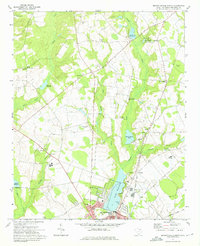 1972 Bennettsville North1975 Print · USGSUpper Marlboro County in the early seventies shows the growing edge of Bennettsville as it meets a landscape of old millponds and rural parishes. Researchers can trace family roots at Oak Ridge Cem or locate community hubs like Newtonville and Old Smyrna Ch.
 - 1972 Map of Bennettsville South, 1976 Print
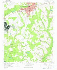 1972 Bennettsville South1976 Print · USGSBennettsville and the southern Marlboro County countryside are shown in detail during the early 1970s. Genealogists and researchers can trace family-named sites such as Driggers Chapel, McCall Cem, and Covington Millpond across this river-and-rail landscape.
End of results
Showing maps 1-2 of 2
Top cities near Bennettsville
- Laurinburg historical maps
- Cheraw historical maps
- McColl historical maps
- Laurel Hill historical maps
- Clio historical maps
- Society Hill historical maps
See more
Top neighborhoods of Bennettsville
Frequently asked questions
- What are the different types of historical maps available for Bennettsville?
- What is the oldest map of Bennettsville?
- Where can I purchase historical maps of Bennettsville for my home or office?
- Where can I download high-res historical maps of Bennettsville?
- Are there historical topographic maps available for Bennettsville?
- Is there historical aerial imagery available for Bennettsville?
- Where are historical maps of Bennettsville sourced from?