1940s Maps of Converse Heights, Spartanburg
Explore 4 historic maps of Converse Heights from the 1940s. These maps offer a rare glimpse into what life looked like during the 1940s — showing old roads, neighborhoods, homes, and landmarks that have changed or disappeared over time.
Whether you're researching your family's past, planning a metal detecting trip, or studying how Converse Heights's landscape evolved across the 1940s, these high-resolution maps are a powerful tool for exploring the history of this region.
- Focus on a specific era: All maps on this page are from the 1940s, giving you a focused view of this time period.
- See what’s changed: Compare century-old streets, trails, and buildings to today's modern landscape using overlays and satellite layers.
- Research with precision: Use these maps for genealogy, historical research, land use analysis, or educational projects.
- View, download, or print: Maps are fully viewable online in high resolution, and can be downloaded or printed for your own records.
Start exploring Converse Heights's history through authentic maps from the 1940s. This is your window into the past.
Converse Heights, Spartanburg maps
(4)- 1941 Map of Spartanburg
 1941 Spartanburg1941 Print · USGSSouth Carolina’s Piedmont and Sandhills regions are shown here during the mid-century peak of the rail era. Researchers can trace the sprawling Fort Jackson Military Reservation and the industrial growth of hubs like Spartanburg and Rock Hill.
 - 1947 Map of Spartanburg, 1969 Print
 1947 Spartanburg1969 Print · USGSSpartanburg and its surrounding mill towns are captured here in the late 1940s, a period defined by rail commerce and military presence. Researchers can trace family roots through numerous local landmarks like Hammett Grove Ch, Glenn Springs, and the sprawling grounds of Camp Croft.
 - 1949 Map of Spartanburg
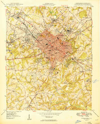 1949 Spartanburg1949 Print · USGSSpartanburg was a thriving railroad and industrial center in the late 1940s, defined by its textile mills and historic colleges. Trace the legacy of early local institutions and family names at Wofford College, Lincoln Memorial Cem, and Hayne Sta.3 unique versions available
 - 1949 Map of Spartanburg
 1949 Spartanburg1949 Print · USGSSpartanburg and its surrounding mill villages are captured here during the post-war industrial era. Genealogists can trace family roots through numerous rural landmarks like Hammett Grove Ch, Stone Station, and the sprawling grounds of Camp Croft.
End of results
Showing maps 1-4 of 4
Frequently asked questions
- What are the different types of historical maps available for Converse Heights?
- What is the oldest map of Converse Heights?
- Where can I purchase historical maps of Converse Heights for my home or office?
- Where can I download high-res historical maps of Converse Heights?
- Are there historical topographic maps available for Converse Heights?
- Is there historical aerial imagery available for Converse Heights?
- Where are historical maps of Converse Heights sourced from?