Old Maps of Springfeild, Spartanburg County
Explore 33 old maps of Springfeild, spanning from 1907 to today. These high-resolution historic maps reveal how streets, neighborhoods, landmarks, and natural features evolved over time — perfect for genealogy, metal detecting, research, and local history exploration.
What you can do with these maps:
- See how Springfeild changed over time: Compare historical maps to modern-day views to trace roads, homesites, rail lines & more.
- View detailed metadata: Each map includes creators, publishers, year, scale, and archive source.
- Overlay maps with satellite & LiDAR: Visualize the past alongside modern tools to explore terrain & human change.
- Trusted historical sources: Maps sourced from the USGS, Library of Congress, and other archives.
- Access maps your way: View online, download high-res files, or order prints for personal or research use.
Start exploring old maps of Springfeild to uncover forgotten places, hidden landmarks, and the deep history beneath your feet.
Springfeild, Spartanburg County maps
(33)- 1907 Map of Saluda
 1907 Saluda1907 Print · USGSCovers Springfeild, including Greer, Hendersonville, and other nearby areas3 unique versions available
 - 1935 Map of Greer
 1935 Greer1935 Print · USGSCovers Springfeild, including Greer, Simpsonville, and other nearby areas
 - 1938 Map of Greer
 1938 Greer1938 Print · USGSCovers Springfeild, including Greer, Simpsonville, and other nearby areas2 unique versions available
 - 1941 Map of Spartanburg
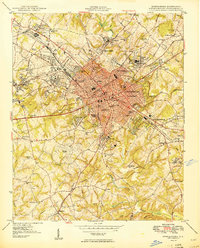
 1941 Spartanburg1941 Print · USGSCovers Springfeild, including Columbia, Rock Hill, and other nearby areas
 - 1947 Map of Spartanburg, 1969 Print
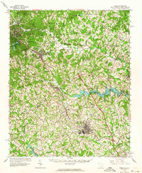
 1947 Spartanburg1969 Print · USGSCovers Springfeild, including Spartanburg, Pacolet, and other nearby areas
 - 1949 Map of Spartanburg
 1949 Spartanburg1949 Print · USGSCovers Springfeild, including Spartanburg, Roebuck, and other nearby areas3 unique versions available
 - 1949 Map of Spartanburg
 1949 Spartanburg1949 Print · USGSCovers Springfeild, including Spartanburg, Pacolet, and other nearby areas
 - 1953 Map of Spartanburg, 1966 Print
 1953 Spartanburg1966 Print · USGSCovers Springfeild, including Columbia, Rock Hill, and other nearby areas4 unique versions available
 - 1953 Map of Charlotte, 1968 Print
 1953 Charlotte1968 Print · USGSCovers Springfeild, including Charlotte, Winston-Salem, and other nearby areas3 unique versions available
 - 1954 Map of Charlotte
 1954 Charlotte1954 Print · USGSCovers Springfeild, including Charlotte, Winston-Salem, and other nearby areas2 unique versions available
 - 1954 Map of Greenville, 1965 Print
 1954 Greenville1965 Print · USGSCovers Springfeild, including Athens, Greenville, and other nearby areas2 unique versions available
 - 1955 Map of Knoxville
 1955 Knoxville1955 Print · USGSCovers Springfeild, including Knoxville, Asheville, and other nearby areas
 - 1957 Map of Greer, 1959 Print
 1957 Greer1959 Print · USGSCovers Springfeild, including Greer, Simpsonville, and other nearby areas2 unique versions available
 - 1957 Map of Knoxville, 1966 Print
 1957 Knoxville1966 Print · USGSCovers Springfeild, including Knoxville, Asheville, and other nearby areas4 unique versions available
 - 1958 Map of Greenville
 1958 Greenville1958 Print · USGSCovers Springfeild, including Athens, Greenville, and other nearby areas
 - 1959 Map of Cowpens, 1961 Print
 1959 Cowpens1961 Print · USGSCovers Springfeild, including Cowpens, Chesnee, and other nearby areas2 unique versions available
 - 1960 Map of Knoxville
 1960 Knoxville1960 Print · USGSCovers Springfeild, including Knoxville, Asheville, and other nearby areas2 unique versions available
 - 1960 Map of Charlotte
 1960 Charlotte1960 Print · USGSCovers Springfeild, including Charlotte, Winston-Salem, and other nearby areas2 unique versions available
 - 1960 Map of Spartanburg
 1960 Spartanburg1960 Print · USGSCovers Springfeild, including Columbia, Rock Hill, and other nearby areas
 - 1961 Map of Inman, 1964 Print
 1961 Inman1964 Print · USGSCovers Springfeild, including Inman, Landrum, and other nearby areas
 - 1962 Map of Charlotte
 1962 Charlotte1962 Print · USGSCovers Springfeild, including Charlotte, Winston-Salem, and other nearby areas
 - 1964 Map of Spartanburg
 1964 Spartanburg1964 Print · USGSCovers Springfeild, including Columbia, Rock Hill, and other nearby areas
 - 1964 Map of Knoxville
 1964 Knoxville1964 Print · USGSCovers Springfeild, including Knoxville, Asheville, and other nearby areas
 - 1983 Map of Inman
 1983 Inman1983 Print · USGSCovers Springfeild, including Inman, Boiling Springs, and other nearby areas
 - 1983 Map of Spartanburg
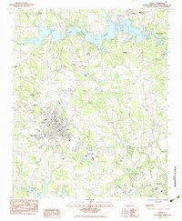
 1983 Spartanburg1983 Print · USGSCovers Springfeild, including Spartanburg, Roebuck, and other nearby areas
Showing maps 1-25 of 33
Frequently asked questions
- What are the different types of historical maps available for Springfeild?
- What is the oldest map of Springfeild?
- Where can I purchase historical maps of Springfeild for my home or office?
- Where can I download high-res historical maps of Springfeild?
- Are there historical topographic maps available for Springfeild?
- Is there historical aerial imagery available for Springfeild?
- Where are historical maps of Springfeild sourced from?